Nội dung toàn văn Circular No. 34/2010/TT-BTNMT on the oceanographical chemical and environmental
THE MINISTRY OF NATURAL RESOURCES AND ENVIRONMENT | SOCIALIST REPUBLIC OF VIETNAM |
No. 34/2010/TT-BTNMT | Hanoi, December 14, 2010 |
CIRCULAR
ON THE OCEANOGRAPHICAL, CHEMICAL AND ENVIRONMENTAL SURVEYS IN INSHORE AREAS ON ISLANDS
THE MINISTER OF NATURAL RESOURCES AND ENVIRONMENT
Pursuant to the Government's Decree No. 25/2008/ND-CP on March 04, 2008 defining the functions, tasks, powers and organizational structure of the Ministry of Natural Resources and Environment;
Pursuant to the Government's Decree No. 25/2009/ND-CP on March 06, 2009 on the general management of natural resources and the protection of oceanic and island environment
At the proposal of the Director of the General Department of Vietnam’s Sea and Islands, the Director of the Science and Technology Department, the Director of the Legal Affairs Department,
PRESCRIBES:
Article 1. Promulgating together with this Circular the Technical Regulation on the oceanographical, chemical and environmental surveys in inshore areas on islands.
Article 2. This Circular takes effect on February 01, 2011.
Article 3. The Ministries, Heads of ministerial-level agencies and Governmental agencies, the President of the People’s Committee of the coastal provinces and cities affiliated to the Central, the Director of the General Department of Vietnam’s Sea and Islands, Heads of Ministerial units and relevant organizations and individuals are responsible for the implementation of this Circular./.
| FOR THE MINISTER |
REGULATION
ON THE OCEANOGRAPHICAL, CHEMICAL AND ENVIRONMENTAL SURVEYS IN INSHORE AREAS ON ISLANDS
(promulgated together with the Circular No. 34/2010/TT-BTNMT on December 14, 2010 of the Minister of Natural Resources and Environment)
Chapter 1.
GENERAL PROVISIONS
1. Scope of regulation
This Circular specifies the order, contents and requirements for the oceanographical, chemical and environmental surveys in inshore and island areas of which the depth is of 0 – 20 meters within the territorial sea of Vietnam, applicable to the following works:
a) Oceanic meteorological surveys;
b) Oceanographical surveys;
c) Oceanic environmental and chemical surveys;
d) Seafloor terrain surveys;
a) Oceanic ecological surveys;
2. Subjects of application
This Circular is applicable to agencies, organizations and individuals engaged in the oceanographical, chemical and environmental surveys in inshore and island areas
The agencies, organizations and individuals engaged in the oceanographical, chemical and environmental surveys in inshore and island areas must comply with this Circular and the International Agreements to which Vietnam is a signatory.
3. General principles of the oceanographical, chemical and environmental surveys in inshore areas on islands
a) Complying with the order, process and regulations on each kind of works when carrying out surveys;
b) The surveys must reflect the particularity of the natural conditions of the surveyed areas.
c) The surveys must comply with the law provisions on environment protection, the conservation of sea, cultural and historical relics, submarine and floating constructions on the sea without obstructing the maritime economic activities;
d) Complying with the provisions on labor safety during the oceanic surveys;
Any unusual figures detected during the oceanographical, chemical and environmental surveys in inshore and island areas must be inspected and surveyed again.
e) Inspecting, appraising the quality and volume of works after the duties are performed;
g) Complying with the provisions on the management of specialized projects belonging to the Ministry of Natural Resources and Environment.
4. Interpretation of terms
a) Wide stations are stations that only carry out observation once after the ship takes position, then move to other stations to observe the changes of the oceanic resources and environment spatially;
b) Continuous stations are stations that carry out observations continuously (for many hours or many days) to observe the chronological variation of resources and environment and their relations.
c) The observation level, is the vertical distance from the calm sea surface at the observation time.
5. Subjects and rates of measurement
No. | Work | Subject of measurement | Figure collection method | |
Wide station | Continuous station (1 – 15 days) | |||
1 | Surveys of oceanic meteorology | Wind, cloud volume; visibility, air pressure, air temperature, air humidity, and other phenomena (specified in the Norm for surface meteorological observation No. 94 TCN6-2001) | Once at all the survey stations | At 1, 4, 7, 10, 13, 16, 19 and 22 o’clock every day |
2 | Oceanographical surveys | Sea waves | Once visual observation at all the stations | 1 hour for a figure (observed by profiler) |
Water level | No observation | 10 minutes for a figure | ||
The current | Once at all the survey stations | 1 hour for a figure (by direct measurement devices), 15 minutes for a figure (by profiler) | ||
The transparency of seawater | Once at all the survey stations | At 7, 10, 13, 16 o’clock every day | ||
3 | Oceanic environmental and chemical surveys | Turbidity, pH level, dissolved oxygen (DO), seawater salinity and temperature | Once at all the survey stations | At 1, 4, 7, 10, 13, 16, 19 and 22 o’clock every day |
Nutritious oil and salt ( | Once at some survey stations | At 1, 4, 7, 10, 13, 16, 19 and 22 o’clock in one day | ||
5 | Seafloor terrain surveys | Measuring the depth and terrain of the seafloor, locating the sampling points and the observation station position. | Once at all the survey stations | Once at all the survey stations |
6 | Surveys of oceanic ecology | Plankton | Once at all the survey stations | At 1, 4, 7, 10, 13, 16, 19 and 22 o’clock every day |
Oceanic fish, seafloor animals, seaweed, coral, mangroves | Once at all the survey stations | Once at all the survey stations | ||
6. Primary measurement devices
No. | Device | Subject of measurement | Measuring range | Resolution | Accuracy |
1 | Current profiler Compact EM | Velocity | 0 ÷ ± 500cm/s | 0.02cm/s | ± 1cm/s |
Direction | 0 ÷ 3600 | 0,010 | ± 20 | ||
2 | Acoustic Wave and Current profiler | Wave height | 0 ÷ 20m | 0.005m | 0.02m |
Wave direction | 0 ÷ 3600 | 0.010 | ± 20 | ||
Tide | 0 ÷ 20m |
| 0.25% | ||
Current speed | 0 ÷ ± 500cm/s | 0.02cm/s | ± 1cm/s | ||
Current direction | 0 ÷ 3600 | 0.010 | ± 20 | ||
3 | Direct reading current meter AEM213-D | Current speed | 0 ÷ ± 250cm/s | 0.1cm/s | ± 2% or 1cm/s |
Current direction | 0 ÷ 359.90 | 0,10 | ± 20 | ||
Depth | 0 ÷ 50m | 0.01m | ± 0.3% of the measuring range | ||
4 | Tide recorder TD304 | Pressure | 0 ÷ 50m | ± 0.01% of the measuring range (0 – 350C) | ± 0.001% of the measuring range |
Temperature | -2 ÷ 400C | ± 0.010C | 0.0010C | ||
5 | Water Quality Meter W22-XD | pH | 0 ÷ 14 | 0.01 pH | ± 0.1 pH |
DO | 0 ÷ 20mg/l | 0.01 mg/l | ± 0.2mg/l | ||
Conductivity | 0 ÷ 10S/m | 0.1% of the measuring range | ± 3% | ||
Salinity | 0 ÷ 4% | 0,01% | ± 0,3% | ||
Temperature | 0 ÷ 550C | 0.010C | ± 1.00C | ||
Turbidity | 0 ÷ 800NTU | 0.1NTU | ± 5% | ||
Total dissolved solids (TDS) | 0 ÷ 100g/l | 0,1% | ± 5g/l | ||
6 | Water Quality Meter WQC-24 | pH | 0 ÷ 14 |
| ± 0.05 pH |
DO | 0 ÷ 20mg/l |
| ± 0.1mg/l | ||
Conductivity | 0 ÷ 10S/m |
| ± 1% of the measuring range | ||
Salinity | 0 ÷ 4% |
| ± 0.1% | ||
Total dissolved solids (TDS) | 0 ÷ 100g/l |
| ± 2g/l | ||
Temperature | -5 ÷ 500C |
| ± 0.250C | ||
Turbidity | 0 ÷ 800NTU |
| ± 3% of the measuring range | ||
7 | Spectrophotometer DR/2010 | Wavelength | 400 – 900nm | 0.5nm | ± 1nm |
8 | Differential Global Positioning System (DGPS) | Coordinate |
|
| ± 3m (horizontally) |
9 | Single beam echo sounder | Depth |
|
| 5cm ± 0.1% D (D: depth) |
10 | Wave rectifier | Rectification |
|
| Measuring waves: 5cm; horizontal, vertical tilt: ± 0.25 degrees |
11 | Compass |
|
|
| ± 0.50 |
12 | Sound velocity meter in water |
|
|
| ± 0.25m/s |
Chapter 2.
PROVISIONS ON THE SURVEYS IN INSHORE AND ISLANDS AREAS
SECTION 1. SURVEYS OF OCEANIC METEOROLOGY
1. Specific principles
a) Complying with the general principles;
b) The surveys of oceanic meteorology must comply with the Norm for Meteorological and oceanographical observation from ships (No. TCN 19-2001) and the Norm for Surface meteorological observation (94-TCN 6-2001) promulgated by the General Department of Meteorology and Hydrology; the Norm for Inshore oceanographical observation (No. 94 TCN 8-2006) promulgated by the Ministry of Natural Resources and Environment, and the instruction documents of the meteorological measurement devices equipped.
2. Preparations
a) Completely preparing and testing the operation of the meteorological measurement devices Preparing spare devices;
b) Check the expiry date of the inspection documents. If the assessment documents are expired, the meteorological measurement devices must be reinspected;
c) Prepare documents serving the observation and calculation;
d) Prepare the supplies and stationery serving the surveys of oceanic meteorology
dd) Prepare labor protection equipment;
e) Requirements for persons in charge of preparation: major observers level 3 or above.
3. The survey works
3.1. Gauging air humidity and temperature
a) Bring the humidity gauge to the position before the gauging time 15 minutes in winters, or 10 minutes in summers;
b) Wind up the ventilator and moisten the cloth covering the mercury bulb of the thermometer on the right (wet-bulb thermometer) before the observation 4 minutes;
c) Hang the humidity gauge on the outer side of the upwind side of the ship;
d) After the ventilator runs for 3 minutes, read the value on the dry thermometer (on the left) and then on the wet-bulb thermometer (on the right) Read the decimal first, and then the integer and write the results in the oceanic meteorology observation sheet
dd) Cleaning and storing the humidity gauge after the work is done;
e) Requirements for persons in charge of air pressure and temperature gauge: major observers level 3 or above.
3.2. Gauging air pressure
a) Put the barometer on the shelf at a height of about 1.4 m in the cabin or another place that is not affect by the heat from the engine, the kitchen or the heat;
b) Do not move or shift the barometer;
c) Open the barometer cover and read the value while gauging;
d) Gently tap the glass cover of the barometer and read the air pressure value;
dd) Write the results in the oceanic meteorology observation sheet;
e) Close the barometer cover and read the value after the work is done;
g) Requirements for persons in charge of air pressure and temperature gauge: major observers level 3 or above.
3.3. Gauging wind
a) When the time comes, bring the wind meter, stopwatch and compass to the gauging position;
b) Put the wind meter on the cabin roof at an open place, record the height above the sea level of the wind meter, read and record the initial value on the meter;
c) Keep the wind meter so that the meter axis is vertical over the head and face the observer, and hold the stopwatch in the other hand. Simultaneously activate the stopwatch and raise the brake pin so that the meter may starts to work. Hold the wind meter in such position in 100 seconds and then pull down the brake pin. Extend the time to 200 seconds or more if the wind is so light;
d) Write the second result in the oceanic meteorology observation sheet;
dd) Measuring the wind direction by a compass;
e) Cleaning and storing the compass, stopwatch and wind meter after the work is done;
g) Requirements for persons in charge of wind gauging: major observers level 3 or above.
3.4. Cloud observation
a) The observer shall visually estimate the general volume of clouds that cover the sky, regardless of the kinds or properties of clouds;
b) The observer shall visually estimate the general volume of lower clouds that cover the sky, including vertical clouds;
c) Identify the kinds of clouds according to the Cloud Atlas of the World Meteorology Organization (WMO) or the cloud classification table;
d) Determining the height of middle and lower clouds under 2,500m height
dd) Write the results in the oceanic meteorology observation sheet;
e) Requirements for persons in charge of wind gauging: major observers level 5 or above.
3.5. Visibility observation
a) The targets of visibility determination must be clearly visible from the observer’s position at an angle less than 5 – 60 with the horizon;
b) Determine the visibility according to the visibility ranking table;
c) Determine both the visibility towards the land and towards the open sea. Write the results in the oceanic meteorology observation sheet;
d) Requirements for persons in charge of wind gauging: major observers level 5 or above.
3.6. Weather phenomena observation
a) Observe the hydrological phenomena: rain, sprinkle, hail, fog, and other phenomena;
b) Observe the phenomena: mist, smoke, and other phenomena;
c) Observe the phenomena: storm, lightning, and other phenomena;
d) Write the results in the oceanic meteorology observation sheet;
dd) Requirements for persons in charge of wind gauging: major observers level 5 or above.
4. Data processing
a) Calibrate the results of air humidity and temperature according to the inspection document, use the humidity table to calculate the relative and absolute humidity, the saturation difference, dew point.
b) Adjust the results of air pressure measurement: calibrate the scale, the temperature, and other additional calibration. Convert the air pressure into the sea level;
c) Calibrate the wind measurement results: convert the number of rounds into wind speed according to the inspection documents;
d) Calculate the particularity of each meteorological elements;
d) Find the trend, the chronological and spatial variation of the meteorology elements;
e) Requirements for persons in charge of data processing: major observers level 4 or above.
5. Assessment and handover
a) Inspect the volume of work done, appraise and assess the results of the surveys;
b) Assess the data collected, and compare them to the general rule of the weather events in the surveyed areas, and their impacts on other elements) Make reports on the results, sum up and learn experience for later surveys
6. Products submitted
a) The data book about the survey results of oceanic meteorological elements;
b) The particularity, the maximum, minimum and average value of the elements;
c) The trend, the chronological and spatial variation of the elements;
d) The summary report on the weather developments, the summary, comments and assessment about the surveys of oceanic meteorology.
SECTION 2. OCEANOGRAPHICAL SURVEYS
1. Specific principles
a) Complying with the general principles;
b) The oceanographical surveys must comply with the Norm for Meteorological and oceanographical observation from ships (No. TCN 19-2001) promulgated by the General Department of Meteorology and Hydrology; the Norm for Inshore oceanographical observation (No. 94 TCN 8-2006) promulgated by the National Meteorology and Hydrography Service, and the instruction documents of the oceanographical measurement devices.
2. Preparations
a) Install the drivers of the current meter, wave meter and water level meter on the computer;
b) Check the connection and data transmission between the current meter, wave meter and water level meter, and the computer;
c) Completely prepare and test the operation of the oceanographical measurement devices;
d) Prepare spare devices;
dd) Prepare documents serving the surveys;
e) Prepare the supplies and stationery serving the oceanographical surveys;
g) Prepare labor protection equipment;
h) Requirements for persons in charge of preparations: major observers level 3 or above.
3. The survey works
3.1. Visual observation
a) Find the wave direction using the compass;
b) Estimate the heights of waves by eyes;
c) Observe the heights of waves continuously in 5 minutes;
d) Record the heights of waves observed in 5 minutes to the paper, and write the heights of the 5 tallest waves in the oceanographical observation sheet;
dd) Underline the tallest wave and find the corresponding wave level;
e) Requirements for persons in charge of visual wave observation: major observers level 4 or above.
3.2. Gauge the waves using the Acoustic Wave and Current profiler (AWAC) or the equivalent.
a) Install the battery for the wave measurement instrument, connect the instrument to the computer;
b) Set up the measurement parameters, format the memory;
c) Put a thin layer of silicon on every waterproof washer of the wave measurement instrument, fit the waterproofing dummy lead
d) Install the protection frame for the wave measurement instrument. Calculate the length of the rope for lowering the instrument congruently with the depth surveyed. Attach marking buoys, beacons, and weights to the rope that lowers the instrument in the U-shape;
dd) Lower the wave measurement instrument and ensure the instrument is well balanced;
e) Arrange personnel to watch the wave measurement instrument until the measurement is done;
g) Retrieve the wave measurement instrument when the measurement is done. Wash the instrument by clean water and dry it. Save the data into the computer. Remove the battery, wash the rope, beacons, buoys and other tools. Store the wave measurement instrument in the protecting box;
h) Requirements for persons in charge of wave measurement using profilers: major observers level 4 or above.
3.2. Directly measuring the current using AEM213-D or the equivalent.
a) Checking and calibrating time information;
b) Adjust the contrast of the LCD screen;
c) Carry out Zero offset for depth and current sensors;
d) Using a cotton rope to hang the weight (10kg), must not use chains;
d) Lower the current meter to the expected level, the lowering speed is 0.5 m/s. Stop, record the direction and speed of the current into the current observation book. Save the data of the current direction and speed in the instrument memory.
e) Retrieve the instrument, wash and clean the instrument, the rope and the display when the measurement is done. Store the current meter in the protecting box;
g) Requirements for persons in charge of wave measurement using profilers: major observers level 5 or above.
3.$. Measuring the current using Compact-EM or the equivalent.
a) Install the battery for the current meter, connect the current meter to the computer;
b) Set up the measurement parameters, format the memory;
c) Put a thin layer of silicon on every waterproof washer of the wave measurement instrument, put on the cover, tighten the screws;
d) Calculate the length of the rope for lowering the instrument congruently with the depth surveyed, the position of the current meter at the right level. Attach marking buoys, beacons, and weights to the rope that lowers the instrument in the U-shape;
dd) Lower the current meter, ensure that the rope is vertical, the tilt of the rope must not exceed 100;
e) Arrange personnel to watch the current meter until the measurement is done.
g) Retrieve the current meter when the measurement is done. Wash the instrument by clean water, dry it and save the data into the computer. Remove the battery, wash the rope, beacons, buoys and other tools. Store the current meter in the protecting box;
h) Requirements for persons in charge of current measurement using current profilers: major observers level 5 or above.
3.5. Measuring the flow using acoustic Doppler current profilers (ADCP)d)
3.5.1. Install the ADCP's driver on the computer.
3.5.2. Set up the instrument
a) Remove the protective dummy plug of the sensor;
b) Connect the sensor to I/O cable;
c) Attach the sensor to the frame;
d) Install the power supply unit.
3.5.3. Set up the connection between ADCP and the computer, create the configuration file.
3.5.4. Enter the parameters of the ADCP
a) Calibrate the depth of the sensor;
b) Calibrate the time;
c) Calibrate the differentials of the sensors;
d) Calibrate vertical deviation of the sensor;
dd) Calibrating the compass
e) Calibrating the variation of the magnetic field;
g) Enter the water salinity;
h) Enter the sound transmission speed in water;
i) Enter the water flow extrapolation;
k) Offset the angle of longitudinal slope and transverse oscillation of the ship;
I) Enter the coefficient of absorption of sound intensity in water
3.5.5. Enter the parameters of the data, the ship, the transect.
a) Enter the folder storing the measurement data;
b) Enter the method of averaging;
c) Enter the thickness of a depth level;
d) Enter the number of depth levels;
dd) Enter the biggest depth of the transect;
e) Enter the mode of ultrasonic wave transmission of ADCP;
g) Enter the speed of the mean on the transect.
3.5.6. Measuring the water flow
a) Configure the ADCP;
b) Record the measurement data into the computer;
c) Start the ultrasonic wave transmission, read and record the water level at the beginning of the measurement;
d) Slowly take the mean offshore until the depth is appropriate for displaying a value of the flow between the two top depth layers (ΣQ ≠ 0), calculate the distance from the ADCP to the beginning shore, enter the calculated distance into the computer;
dd) Move the mean vertically at appropriate speed no exceeding 1.5 m/s;
e) Keep vertically moving until reaching the depth is appropriate for displaying a value of the flow between the two top depth layers, stop and calculate the distance from the ADCP to the ending shore, enter the calculated distance into the computer; Stop the ultrasonic wave transmission, end the measurement. Write the measurement data on the sheet of flow measurement using ADCP.
3.5.7. Finishing the measurement
a) Remove the power supply unit from the sensor;
b) Cover the sensor, remove the instrument from the frame;
c) Remove the plug from the sensor;
d) Fit the dummy plug to the sensor;
dd) Retrieve the I/O cable, rinse the sensor by clean water, dry and put the sensor in the housing.
3.6. Measure the water level using the TD304 recorder or the equivalent.
a) Install the battery for the tide recorder and connect it to the computer;
b) Set up the measurement parameters, format the memory;
c) Put a thin layer of silicon on every waterproof washer of the tide recorder;
d) Install the protection frame for the tide recorder. Calculate the length of the rope for lowering the tide recorder congruently with the depth surveyed. Attach marking buoys, beacons, and weights to the rope that lowers the instrument in the U-shape;
d) Start and lower the tide recorder;
e) Arrange personnel to watch the tide recorder until the measurement is done;
g) Retrieve the water level recorder when the measurement is done. Wash the instrument by clean water and dry it. Save the data into the computer. Remove the battery, wash the rope, beacons, buoys and other tools. Store the tide recorder in the protection box;
h) Requirements for persons in charge of water level measurement: major observers level 4 or above.
3.7. The transparency of seawater
a) Observe the transparency on the shaded side of the ship. Stay from the sewage discharge area of the ship and the oil scum area of the water surface;
b) Use the winch to lower the secchi disk until it touches the water, mark the position as 0, then continue lowering the disk until it is not visible, the pull it up and down several times at such depth.
c) Measure 3 times, take the average depth and write the results on the oceanographical observation sheet;
d) Requirements for persons in charge of wind gauging: major observers level 3 or above.
4. Data processing
a) Use STORM software to process wave data, export the data into EXCEL files;
a) Use WINCEM software to process flow data, extract the data into CSV files;
c) Use MINISOFT SD2000W software to process water level data, export the data into EXCEL files;
c) Use TRANSECT software to process water flow measurement data, export the data into TEXT files;
d) Make the table of rates, calculate the regulation constant, describe the flow and its particularity;
e) Find the wave characters: direction, cycle, height, prevailing direction and
g) Draw the graph of water level variation;
h) Adjust the transparency data;
i) Find trend and the chronological and spatial variation of the elements;
k) Calculate and find particularity, the maximum, minimum and average value of the elements;
l) Requirements for persons in charge of data processing: major observers level 3 or above.
5. Assessment and handover
a) Inspect the volume of work done, appraise and assess the results of the surveys;
b) Assess the data collected. Find the particularity and rules of the oceanographical elements in the sea area surveyed, and their impacts on other elements;
c) Make reports on the results, sum up and learn experience for later surveys
6. Products submitted
a) The data book about the survey results of oceanographical elements;
b) The particularity, the maximum, minimum and average value of the elements;
c) The table of rates, the regulation constant, the flow drawings and its particularity;
d) The wave characters: direction, cycle, height, prevailing direction and the wave drawings
dd) The graph of water level variation;
e) The summary report and assessment of the results of oceanographical surveys.
SECTION 3. OCEANIC ENVIRONMENTAL AND CHEMICAL SURVEYS
1. Specific principles
a) Complying with the general principles;
b) The surveys of oceanic environment must comply with the Standard No. TCVN 5993 – 1995, TCVN 5998 – 1995, the Norm for Meteorological and oceanographical observation on ships (No. TCN 19-2001) and the Norm for Inshore oceanographical observation (No. 94 TCN 8-2006) on the temporary provisions on hydrological and atmospheric environmental observation promulgated by the General Department of Meteorology and Hydrology.
2. Preparations
a) Calibrate, prepare and test the chemical analysis and environmental measurement devices;
b) Prepare and check the equipment for sampling and stirring;
c) Prepare spare equipment and devices;
d) Prepare tools for specimen storing and analyzing.
dd) Prepare preservatives for the specimens;
e) Prepare documents serving the observation and specimen analysis;
g) Prepare labor protection equipment;
h) Prepare the observation sheet, logbook, supplies, chemicals, and stationery;
i) Requirements for persons in charge of preparations: major observers level 3 or above.
3. The survey works
3.1. Sampling the oceanic environment
a) Take specimens on the upwind side of the ship using the bathometer, stay from the area polluted by the sewage of the ship;
b) The bathometer must be attach to a weight to make sure the sampling rope is not oblique;
c) Lower the bathometer to the right sampling level;
d) Take specimen for measuring sea turbidity, temperature, salinity, DO and pH at the surface, the middle and the seafloor. The volume of water specimen is 2 liters;
D) Take specimens for measuring nutritious salt (NO2-, NO3-, NH4+, PO43-, SiO32-) at the surface, the middle and the seafloor. The volume of water specimen is 2 liters;
D) Sample the heavy metal (Cu, Pub, Cod, Fe, Zn, Ni, Man, As, Hg) at the surface, the middle and the seafloor. The volume of water specimen is 2 liters;
g) Sample the oil at the surface The volume of water specimen is 2 liters;
h) Requirements for persons in charge of oceanic environment sampling: major observers level 3 or above.
3.2. Sampling the atmospheric environment
a) The sampling position must ensure that the atmosphere is not partially polluted by the ship operation;
b) Find the wind direction, measure the wind speed. Observe and make preliminary judgment about the weather;
c) Select the position and firmly fix the instrument to an appropriate position;
d) Pump the absorption liquid, keep the prepared specimen to the corresponding tubes and fix to the atmosphere sampling position. Set the timer on HS-7 sampler, check the rotameter, set the appropriate flow, start the generator;
dd) Send the specimens to the analysis and storage division after finishing sampling;
e) Record the coordinates of the beginning, ending position, the beginning and ending time of the sampling if the specimens are taken on a journey;
g) Dust sampling time: PM10 in 24 hours, SO2 in 1.5 hours, NOx in 1 hour, l O3 in 1 hour, sampling CO, CO2 in 20 minutes;
h) Requirements for persons in charge of oceanic environment sampling: major observers level 4 or above.
3.3. Preserving specimens
The technique for water specimen storage to be analyzed:
No. | Parameters | Symbol | Type of tank | Storage conditions | Maximum period | Notes |
1 | Oil |
| G | Extracted with carbon tetrachloride (CCl4) cold storage | 1 month |
|
2 | Chemical oxygen demand | COD | P or G | Acidize until pH < 2="" using="">2SO4, kept in cold storage 4 – 50C | 5 – 7 days | 10 – 15 days in 2 – 50C cold storage |
3 | Biochemical oxygen demand | BOD | P or G | Cold 4 – 50C | 24 hours |
|
4 | Copper Nickel Zinc Cadmium Manganese Iron | Cu Ni Zn Cd Mn Fe | P or G | Acidize until pH < 2="" using=""> | 1 month | 2,000 ml |
5 | Mercury Arsenic Lead | Hg As Pb | P or G | Acidize until pH < 2="" using="">3 | 1 month | 2,000 ml |
Notes:
Vml: the volume of specimens to be taken
P: plastic
G: glass
a) Storing oil specimens: mist 2 liters of water samplers with 40 ml of carbon tetrachloride (CCl4). Stir the mixture in 30 – 40 minutes using a magnetic stirring machine. Use the pipette to extract the CCl4 at the bottom and put on a stoppered glass jar. Write the sampling position and time on the specimen jar. Store specimens in a dark room at 40C;
b) Storing COD, BOD specimens: mix 4 ml of concentrated H2SO4 with 2 liters of seawater specimens. Write the sampling position, level and time on the specimen can. Store the specimens at 4 – 50C;
c) Storing heavy metal specimens (Cu, Cd, Fe, Zn, Ni, Mn): acidize 2 liters of seawater specimen until pH<2 by="" 4ml="" of="" concentrated="" hcl.="" write="" the="" sampling="" position,="" level="" and="" time="" on="" the="" specimen="" can.="" store="" the="" specimens="" in="" normal="">
d) Storing heavy metal specimens (Pb, As, Hg): acidize 2 liters of seawater specimen until pH<2 by="" 4ml="" of="" concentrated="">3. Write the sampling position, level and time on the specimen can. Store the specimens in normal conditions;
dd) Storing the atmosphere specimens: store the specimens of SO2, NOx, O3, CO, CO2 in a temperature conditioner. Store the glass filter papers of PM10 dust sampler in nylon bags in a dry environment;
e) Requirements for persons in charge of specimen storage: major observers level 3 or above.
3.4. Measuring seawater turbidity, DO, pH, salinity, and temperature WQC24, or W22-XD, or equivalent instruments.
a) Connect the battery to the DO, pH, salinity, temperature, turbidity meter;
b) Test the automatic pH sensor using pH4 solution;
c) Immerse the sensor in the measured water. Measure the seawater temperature and DO first, then the salinity, turbidity, and pH last;
d) Write the results in the oceanic meteorology observation sheet;
dd) Requirements for persons in charge of air pressure and temperature gauge: major observers level 3 or above.
3.5. Measure the nutritious salts using DR/2010 Spectrophotometer (under the instruction of HACH) or equivalent instruments.
a) Measuring nitrites (NO2-): using the nitrite measurement program No. 371, at the wavelength 507 nm. Add nitrite measurement substance in a 10ml jar holding the specimen. Wait 20 minutes until the color completely appears, then take into the specimen measurement chamber, and read the nitrite measurement results. Write the results in the environmental chemical observation sheet;
b) Measuring nitrates (NO3): using the nitrite measurement program No. 351, at the wavelength 507 nm. Add nitrate measurement substance in a 25ml jar holding the specimen. Wait 15 minutes until the color completely appears, then take into the specimen measurement chamber, and read the nitrate measurement results. Write the results in the environmental chemical observation sheet;
a) Measuring ammonium (NH4): using the ammonium measurement program No. 385, at the wavelength 655 nm. Add nitrate measurement substance in a 10ml jar holding the specimen. Wait 18 minutes until the color completely appears, then take into the specimen measurement chamber, and read the ammonium measurement results. Write the results in the environmental chemical observation sheet;
a) Measuring phosphate (PO43-): using the ammonium measurement program No. 490, at the wavelength 890 nm. Add phosphate measurement substance in a 10ml jar holding the specimen. Wait 2 minutes until the color completely appears, then take into the specimen measurement chamber, and read the phosphate measurement results. Write the results in the environmental chemical observation sheet;
a) Measuring silicate (SiO32-): using the ammonium measurement program No. 651, at the wavelength 815 nm. Add silicate measurement substance in a 10ml jar holding the specimen. Wait 5 minutes until the color completely appears, then take into the specimen measurement chamber, and read the silicate measurement results. Write the results in the environmental chemical observation sheet;
e) Requirements for persons in charge of nutritious salt measurement: major observers level 5 or above.
4. Data processing
a) The specimens of oil, COD, BOD and heavy metal must be analyzed in the laboratory right at the end of the survey;
d) The data must be processed right at the end of the survey;
c) The data processed shall be recorded in the summary observation sheet of meteorology, hydrography and environment TGM – 3, saved on CDs and in computers;
d) Calculate the particularity of each elements;
dd) Draw the graph of the variation of seawater temperature, salinity and other elements;
e) Requirements for persons in charge of data processing: major observers level 3 or above.
5. Assessment and handover
a) Inspect the volume of work done, appraise and assess the results of the surveys;
b) Assess the data collected. Find the particularity and rules of the environmental elements in the sea area surveyed, and their impacts on other elements;
c) Make reports on the results, sum up and learn experience for later surveys
6. Products submitted
a) The data book about the survey results of chemical elements of the oceanic environment;
c) The chronological and spatial variation of the elements;
c) The summary report and assessment of the results of environmental and chemical surveys.
SECTION 4. SEAFLOOR TERRAIN SURVEYS
1. Specific principles
a) Complying with the general principles;
b) The measurement and navigation must be carried out on the VN-2000 coordinate system. The WGS-84 coordinates collected from GPS shall be converted using the parameters prescribed by law provisions on parameter system of conversion from the World Geodetic System WGS-85 to the National coordinate system VN-2000;
c) The depth meter must be accurately calibrated according to the draught of the probe, the rectified tolerance, and the sound speed The impacts of waves such longitudinal and transverse oscillation must be rectified;
d) The software of terrain surveying and navigating must be modern and able to collect and integrate the data from the devices of positioning, depth measurement, wave impact measurement, point location; sending signals and data to peripheral devices. The data from all sources must be store in the database created by the software in order to used for later processing;
dd) Apart from processing the data from various ship surveys, making reports, the products are also used for making and updating the sea bed terrain at scale 1:10,000 or 1: 25,000, and providing original data for the database of the oceanic geographical information system.
2. Preparations
2.1. Receiving and checking the operation of the devices installed on the survey ship.
2.2. Preparing spare devices;
2.3. Receiving and checking the operation of the measurement devices used for examination.
2.4. Set up the parameters for the software.
2.4.1. Select VN-2000 coordinate system, enter the parameters of conversion from WGS-84 to VN-2000.
2.4.2. Enter the connection ports of the devices to the computer, check the connection and data transmission between the devices and the computer.
2.4.3. Enter the measurement route and the targets to take ship to.
a) The depth measurement routes within the ship survey range, parallel with the terrain slope. The distance between the routes must not exceed 100 m for 1:10000 maps, and 250 m for 1:25000 maps;
b) The measurement lines around islands and shores are not necessary. The ship shall run inshore at a safe distance during the cartography;
c) The inspection measurement routes must cut the depth measurement routes at an angle of 60 – 90 degrees, the total length of the inspection line must not be less than 10% the total length of the depth measurement lines.
d) The sampling and observation instrument positions must be designed by a circle of which the radius equals to the tolerance of the sampling and observation instrument positions Each position must be attached to a target in the navigation software
2.5. Prepare the supplies and stationery serving the seafloor cartography
2.6. System installation
2.6.1. The cartography and navigation system used for survey ships in shallow areas includes the devices connected based on the following diagram:
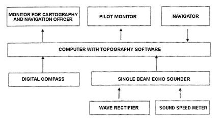
2.6.2. Each device must be firmly installed and comply with the instruction of each device at the most appropriate place on the survey ship.
2.6.3. The antenna of the navigator must be put in open places, able to avoid electromagnetic wave interference and impacts from multiple connections.
2.6.4. The Gyro compass must be firmly placed on a flat surface so that it can show the actual direction of the ship. The two antennae of the satellite compass must be installed similarly to that of the navigator on the same horizontal flat surface.
2.6.5. The transducer of the wave rectifier must be put horizontally near the ship center, towards correct direction in order to minimize the system variances caused by the installation.
2.6.6. The probe of the depth meter must be firmly installed at the best interference-proof place on the survey ship.
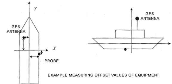
2.6.7. After the finishing the system installation on the ship, carry out the measurement to determine the following elements:
a) The offset of the devices on the survey ship, the ship center, the points showing the size, the shape and the direction of the ship; the place of navigation antennae, compass antennae (satellite compass), the place of the wave rectifier transducer, the place of the depth meter probe, the points of sampling and observation devices, the draft marks;
b) Make the table for the draft variation of the ship by speed and by weight variation;
c) The tilt (vertical tilt, horizontal tilt) of the surface of the rectifier transducer compared to the ship axis;
c) The tilt (vertical tilt, horizontal tilt) of the surface of the depth meter probe compared to the ship axis;
dd) The directional deviation due to the installation of the compass, the probe, and the transducer compared to the ship axis.
2.6.8. The places of the devices must be demonstrated on the coordinate system of which the origin is the ship center, the Y axis is the ship bow direction, the X axis is perpendicular to the Y axis and pointing in the starboard direction. The position tolerance of the offset points compared to the coordinate origin must not exceed ± 1cm. The angle tolerance of the installed devices must not exceed ± 1 degree.
2.7. Testing and calibrating the system
2.7.1. The measurement and navigation devices must be tested under the Regulation on The technique of making seafloor topographical map at scale 1:50,000 promulgated together with the Decision No. 03/2007/QD-BTNMT on February 12, 2008 of the Minister of Natural Resources and Environment.
2.7.2. Test and calibrate the following devices after finishing the system installation and before the survey:
a) Testing the depth meter:
Measure the standard sound speed in water in the surveyed area. Enter the minimum measuring speed of the depth meter. Lower the surveying disk to such minimum depth (± 0.5cm). Use the depth meter to measure the depth of the disk. The difference between the depth measured by the depth meter and the actual depth of the disk is the tolerance of the depth meter. Such tolerance is included in the tolerance of the depth meter (if the depth meter does not have such content, this tolerance shall be added to the submersion level of the probe);
After rectifying the tolerance, lower the depth measurement disk meter by meter, enter the corresponding sound speed of each depth. Measure the depth of the disk by the depth meter, determine the difference between the depth measured and the actual depth. If the difference lies within the tolerance of the instrument, the instrument is considered functional. If the difference exceed the tolerance, the instrument must be replaced;
b)The compass must be tested under the Annex 2 of Regulation on The technique of making seafloor topographical map at scale 1:50,000 promulgated together with the Decision No. 03/2007/QD-BTNMT on February 12, 2008 of the Minister of Natural Resources and Environment.
2.8. Requirements for persons in charge of preparations: major observers level 3 and above, or engineers level 3 and above.
3. The survey works
3.1. Survey navigation
a) Take the ship to the position where the observation station or the sampling device is lowered. The point of These points must be consistent with the designed targets;
b) When the position to lower the instrument lies within the tolerance circle, the ship must be kept stable within such circle to lower the instrument;
c) When the instrument reach the sampling position, such position shall be marked. The data recorded includes: the coordinate of the position to lower the instrument, the depth of the measuring area, the time of marking. The person who lowers the instrument shall record the depth of the instrument;
d) During the entire trip of oceanographical, environmental, chemical surveys, the navigation data shall be recorded chronologically (once every 5 seconds);
dd) Requirements for persons in charge of survey navigation: technicians level 6 or above.
3.2. Tide observation
a) The survey must include tide observation. In case the survey area is outside the area able to use the tide data observed from fixed oceanography stations. The tide data must be connected to the height system of the State;
b)The tide observation from temporary observation stations must comply with the Regulation on The technique of making seafloor topographical map at scale 1:50,000 promulgated together with the Decision No. 03/2007/QD-BTNMT on February 12, 2008 of the Minister of Natural Resources and Environment.
c) Requirements for persons in charge of tide observation: technicians level 6 or above.
3.3. Seafloor depth measurement
a) The measuring ship is navigated by the probe of the depth meter. The ship must not deviate from the line 1mm according to the map scale. The maximum speed of the ship is 8 kph;
b) The ship must reduce speed when it turns to get in the next path and ensure that the wave rectifier is no longer affected by horizontal acceleration;
c) The data of navigation, depth, compass, wave impacts must be continuously recorded by the software throughout the measurement and examination trip;
d) The measurement points must be marked from the beginning of the measurement line. Two adjacent points must not exceed 20m for maps with 1:10000 scale, 50m for maps with 1:25000 scale;
dd) All events during the topographical cartography, the measurement line name, the beginning and ending time, the direction, the data files must be carefully written in the topography book;
e) In case one of the measurement devices breaks down that the data between 2 marking points is lost, that segment must be remeasured;
g) The submersion level of the probe is measured at the beginning and the end of the measurement trip. Notice the measuring time to rectify the submersion level of the probe when processing data;
h) Requirements for persons in charge of seafloor depth measurement: technicians level 6 and above, or engineers level 4 and above.
4. Data processing
a) Edit the tide data, rectify the time of data recording in case there is difference between the time of the tide observation station and the measurement system on the ship. Create the data files compatible with the data processing software;
b) Making the data processing projects separately for each survey project. Import the measurement and tide data to the software;
c) The data of each measurement path is processed and edit separately;
d) Adjust the measurement data based on the data about the sound speed, the submersion of the probe;
dd) Remove the deviation pints of the depth, the wave measurements based on the data transect. Adjust the latency between the depth measurement and wave measurement. Interpolate the points of data loss without measuring again;
e) Assess the measurement accuracy based on the depth measurement and inspection measurement data under the Regulation on The technique of making seafloor topographical map at scale 1:50,000 promulgated together with the Decision No. 03/2007/QD-BTNMT on February 12, 2008 of the Minister of Natural Resources and Environment.
g) Convert the data in form of X, Y, H of the marked points into formats compatible with the map and database editor software;
h) Make the survey report drawings include the topographical measurement paths and points, the station position, the specimens of oceanographical, chemical and environmental surveys;
i) Requirements for persons in charge of data processing: technicians level 10 and above, or engineers level 5 and above.
5. Assessment and handover
a) Inspect the volume of work done, appraise and assess the results of the surveys;
b) Assess the data collected;
c) Make reports on the results, sum up and learn experience for later surveys
6. Products submitted
a) The survey report drawings include the topographical measurement paths and points, the station position, the specimens of oceanographical, chemical and environmental surveys, demonstrated on 1:10000 and 1:25000 maps as specified in the project of oceanographical, chemical and environment survey inshore and island areas;
b) The summary report and preliminary assessment of the results produced in the survey.
SECTION 5. SURVEYS OF OCEANIC ECOLOGY
1. Specific principles
a) Complying with the general principles;
b) The surveys of oceanic ecology must comply with the Law on Biological diversity in 2008;
c) The analysis results are passed when there are 5% of the specimens are sent to be tested. The analysis results and the specimens must be consistent;
d) After the specimens are tested, they must be put in glass jars of alcohol 70% and glycerin 5% for long-term storage.
2. Preparations
2.1. Checking the operation of the devices before each survey.
a) The survey transport: ships, speedboats, motor boats, cars, diving instruments;
c) Equipment for collecting and storing specimens on the spot;
c) Tools for reserves investigation;
d) Tool for storing specimens;
dd) Chemical tools for preserving fresh specimens;
e) The documents for quick classification on the spot;
g) Cameras, computers;
h) The logbook for each group of organisms
i) Clothes, footwear’s, gloves (for labor protection).
2.2. Prepare the devices, tools, supplies, and chemicals.
2.3. Locate the coordinate of the station on the map.
2.4. The position and path of the sampling station must satisfy the criteria
a) Representative;
b) Covering the biotope;
c) Covering the space;
d) Make the sampling diagram enclosed with the coordinates.
2.5. Determine the sampling time: representing the seasons. It is best to specimen every 3 months.
2.6. Determine the groups of organisms to be sampled.
dd) Requirements for persons in charge of preparations: engineers level 6 or above.
3. The survey works
3.1. Phytoplankton
3.1. Sampling
a) Sampling using nets: all kinds of nets are raised vertically from the bottom to the surface. If the raising angle exceed 450, the specimens collected are only for qualitative research not for quantitative research;
b) The net must be raised at a constant speed. The raising speed is 0.5 - 1 m/s for large nets, 0.5 m/s for medium nets, 0.3 – 0.5 m/s for small nets. The net must not be stopped while raising;
c) Add formaldehyde to the specimen jar depending on the water volume until the concentration reaches 5%. The stratified specimens must comply with the hydrographical stratification : 0 – 10m, 10 – 20m. Do not take stratified specimens if the deviation of cable angle exceed 300;
d) Take specimens using a water pump: the minimum volume is 1 liter. Take specimens again if there are contaminants, oil scum, or cephalopods in the specimens. Add sufficient preservatives to the specimen jar to avoid decomposition. Connect a 0.5kg weight to end of the frame with a cod end.
3.1.2. Handling specimens
a) Put the specimens in a jar with appropriate size;
b) The specimen jars must be labeled inside and outside. The labels must be written by non-smudgeable ink on tracing paper. Write the symbol of the surveyed sea area, the kind of net, the collected year and ordinal number of each specimen in each survey;
c) The specimens taken by a water pump must be filtered by a centrifuge. Take out water until 5 – 10 ml left to be stored in small jars. These jars must be labeled;
d) Put the specimen jars from the water levels of each station in a big labeled jar with the station number.
3.1.3. Preservation and transportation
a) The preservatives: Lugol’s solution
b) The specimen jars fully labeled, pencils, glass ink pens (waterproof ink), survey logbook. Plastic jars are usually used for storing specimens in the surveys for easy transportation; The quantitative specimens are store in 1-liter – 5-liter jars depending on the survey areas.
c) The specimen jars are put in metal boxes after sampling, and transported to the laboratory for analysis.
3.1.4. Handling specimens
a) All the specimens collected must be recorded in the specimen register;
b) The register must be double-checked.
3.1.5. Specimen analysis
a) Qualitative specimen analysis: take the qualitative specimens to the laboratory, let them deposit, then take a small amount of sample, put it on the slide and observe it using a microscope. Carry out the succeeding steps such as cleaning, breaking, splitting, or staining depending on typical characteristics. Take pictures of the typical specimens during the observation. Analyze the specimens using the OLYMPUS microscope and the LEICA fluorescence inverted microscope;
b) Quantitative analysis: take the quantitative specimens to the laboratory, let them deposit in darkness in at least 24 – 48 hours. Use a small siphon to gradually draw the water in the specimen jar until the scum appears. Put the specimen in a 100ml graduated cylinder and let it deposit in at least 24 hours. Use a siphon to draw water from the graduated cylinder until the scum appears and let it deposit again. Keep doing that until there is 10 - 20 ml of specimen left in the graduated cylinder. Put the specimen in a small jar (10 – 20 ml) for storage. Shake the specimen jar when analyzing, use a pipette to take 1ml of specimen to the Sedgewick – Rafter counter cell. Count the cell quantity of each species under the LEICA inverted microscope;
c) Use a counting machine for species with high frequency of appearance. Count part, a half, or the entire cell depending on the cell density in the specimen.
d) After counting, put the specimen back to the storage jar. The counting cell and the pipette must be rinse by clean water before counting other specimens;
dd) The analysis results shall be updated on the phytoplankton weight and quantity calculation and sheet.
3.1.6. Requirements for persons in charge of phytoplankton survey: engineers level 3 or above.
3.2. Zooplankton
3.2.1. Sampling
a) Sampling using nets: all kinds of nets are raised vertically. If the raising angle exceed 450, the samples collected are only for qualitative analysis not for quantitative analysis;
b) The net must be raised at steady speed. The raising speed is 0.5 - 1 m/s for large nets, 0.5 m/s for medium nets, 0.3 – 0.5 m/s for small nets. The net must not be stopped while raising;
c) Rinse the outer side so that the organisms so that the organisms go all the way down to the bottom. Then put them in a jar. Add formaldehyde to the specimen jar depending on the water volume until the concentration reaches 5%;
d) The stratified specimens must comply with the hydrographical stratification : 0 – 10m, 10 – 20m. Stop and drop the stratification hammer when the net mouth reach the upper limit of the water level so that it will close. Do not take stratified specimens if the deviation of cable angle exceed 300. Write the stratification sampling results in the sheet;
dd) Take quantitative specimen by the 5-liter bathometer, raise 20 times and filter the water through the net for collecting the plankton specimens. Do not keep more than 200 ml of water with the specimen stored in a plastic jar and fixed by formalin 5%.
3.2.2. Handling specimens
a) Use a pipette covered by sieve cloth No. 38 to reduce the volume of water from the specimen jar, the put the specimen in a small jar with appropriate size;
b) The sample jars must be labeled inside and outside. The labels must be written by non-smudgeable ink on tracing paper. Write the symbol of the surveyed sea area, the kind of net, the collected year and ordinal number of each sample in each survey on the label.
3.2.3. Preservation and transportation
a) Store the specimen collected by the net in the formalin solution 5%;
b) Store the specimen collected by the water pump in the Lugol’s solution 1%;
c) Alcanize the formalin solution with sodium borate or sodium carbonate (Na2CO3) to prevent the corrosion caused by the zooplankton;
d) The specimens are stored in plastic bottles;
dd) After being stored and labeled, the zooplankton specimens shall be put in wooden or metal boxes to deliver to the laboratory.
3.2.4. Specimen registration
a) All the specimens collected must be recorded in the specimen register;
b) The register must be double-checked.
3.2.5. Specimen analysis
a) Qualitative analysis: identify the species using dissecting scopes and microscopes;
b) Identify the class using the dissecting scope;
c) Select the most typical and fully developed individuals to dissect and identify the species using the microscope;
d) Quantitative analysis methods: count every species if the amount of specimen is small. Only count the large-size species if the amount of specimen is large. Record the counting results in the zooplankton counting sheet and the stratified specimen counting results in the stratification zooplankton counting sheet;
dd) Weighing methods: select the species of zooplankton being fish food to weigh the humidity. The minimum sensitivity of the scale must be 0.01mg. Remove the dregs and contaminants be for weighing the specimen using electric scale with the sensitivity being 0.0001g. Filter the specimen through a filter (the mesh size = 315mm). Moisten the specimens by a filter paper until it reaches the natural humidity. Weigh the specimen.
3.2.6. Requirements for persons in charge of zooplankton survey: engineers level 3 or above.
3.3. Seafloor animals
3.3.1. Sampling
a) Sampling using biological dredge: observe and record the status of seafloor substances, thickness, organisms. The volume of substances must reach at least half the dredge. Each station must collect specimens in 0.5 m2. The submersion level of the dredge is 4 – 5 cm if the seafloor substances are sands and shells of medium organisms. 6 – 7 cm if the seafloor substances are fine sand, ≥ 10cm is the seafloor substances are mud. Take specimens again if one of the above criteria is not satisfy. Rinse the specimens through a filter. Pick them up carefully after rinsing, separate the close and species or groups. Large and small individuals may be separated and stored in different jars;
b) Sampling using trawl nets: cast the net while the ship is moving slowly and its direction is steady. The pulling cable length must be appropriate with the ship speed, the depth, the flow and the wind direction. The speed of the ship while pulling the net is 2 – 2.5 knots. The hauling period is 5 – 10 minutes. The quantitative specimens are considered qualified if the net bag is full of seafloor substances. The standard volume of the net bag is 50 liters. Rinse the specimens through a filter;
c) Sampling from tides: sampling from high tides, medium tides and low tides. When the sampling position is located, place a quantitative block ¼ m2 in the tide area and dig 15 – 20 cm of seafloor substances using shovels or knives;
d) Sampling from seaweed reefs: determine the quantity of transect to be collected depending on the size of the reef. It is best to collect 3 transect from each reef. Put 3 sampling samples on each transect, 1 at the beginning, 1 in the middle, and 1 at the end. Collect 3 specimens at each station using the ponnar-dredge and screened using the 2-cell screen;
dd) Sampling from coral reefs: collect the quantitative specimens from the coral line transect. Put 3 – 5 survey station on each line transect. Collect 3 blocks of specimens at each station, each block is 1 m2. The quantitative specimens collected at the stations must match that collected at qualitative sampling stations. Each of the 3 dead corral slab at each sampling station weighs 5 kg. Use the hammer and knife to take all the specimens in the coral slab and submerge them in alcohol 700 and put on labels.
3.3.2. Handling specimens
a) Extracting specimens: take out the specimens, separate plants and animals. Separate animals that need anesthesia and ones that do not. Separate species with soft bodies and ones with shells or thorns;
b) Nourishing and anaesthetizing the specimens before storing so that the specimens may retain their original form as they were alive. Nourish and revive the organisms in clean seawater tanks before anesthesia. Do not put the carnivorous animals, or shelled animal, or fast animals (such as large crustaceans) in the same tanks with other delicate animals. When the animals are recovered and able to live normally, gradually put the anesthetic in (menthol, magnesium sulfate) The anesthetic are inserted in many times with appropriate amount. Soak the animals in preservative liquid when they are completely desensitized;
c) Preservation: after being treated, put the specimens directly in jars containing alcohol 75% or formalin 4-10% to preserve;
d) Qualitative specimens: the plants are retained and submerged in formalin 4%. The medium-sized shelled animals (mollusks or crustaceans), or vertebrates (echinoderms, sponge, coelenterates) are stored in alcohol. The large-sized, fleshy and thick specimens (Nudibranchia, Octpeda) are stored in formalin;
dd) Accurately calculate the organic matter of quantitative specimens. Use formalin 7-10% to retain all organic substances in the organisms’ body. For animals that need micro-surgery for species identification, it is required to use appropriate preservative solution (Bouin, 10% neutral buffer formalin).
3.3.3. Registering and recording specimens
a) The treated specimens must be registered on the field book and on the labels;
b) Registering on the boards: the quantitative board is used for registering quantitative specimens. The qualitative board is used for registering qualitative specimens.
c) Registering on labels and tags: The labels must be made of untearable materials that ensure the writing are not smeared when being soaked in alcohol or formalin for along time. The specimen registration tags must be made of aluminum, plastic, or bamboo. The aluminum and plastic tags must be engrave with numbers. The bamboo tags may be written on using technical black pen. The tags must be uniform and have holes drilled at one side to arrange and store.
3.3.4. Specimen analysis
a) Comparing the specimens, then separate them to be analyzed. The quantitative specimens and qualitative specimens must be separated. Separate the phyla or classes such as: sponge, coelenterates, mollusks, crustaceans, echinoderms;
b) Weigh the alcoholed-specimens using the precision scale with 0.01g sensitivity. Use the scale with 0.01mg sensitivity if the specimen is still used for calculating dry weight. The specimen must be put on blotting paper to drain the surface water. If the nest of the animal is too big, then remove it. If the net is small, then keep it in order to avoid damaging the specimen. It is not required to remove the shell the while weighing mollusks, but all the water or alcohol in the shells must be drained. Remove the shells of large species with considerable amount of individuals, but the shell and the organic body must be separately weighed for reference;
c) Weighing dry mass: after weighing the alcoholed-specimens, the species or groups of species of each station must be processed to collect the data about dry mass. Large specimens belonging to the class of echinoderms polychaetes must be dissected to remove the dregs in their intestines. The species with calcareous skeletons must be treated by diluted hydrochloric acid (HCl 0.1N). Use the precision scale with 0.01mg sensitivity to weigh. The specimen must be taken out of the drier and cooled down in desiccators. Each specimen must be quickly weighed.
3.3.5. Requirements for persons in charge of seafloor animal survey: engineers level 4 or above.
3.4. Algae
3.4.1. Sampling
a) Community survey: the specimens collected for classification or storage must satisfy the following requirements: the specimens are collected in various localities, free-floating or parasitic, including ones growing commensally on other kinds of algae. The specimen must be complete with every part, have reproductive cells or genitals. The specimen must be mature. The minimum quantity of each species is 10 specimens. Or collect all the specimens if the quantity of a species is so small. Use a knife to prise, or a hammer to break the attached base to collect the specimens. Other kinds of algae may be collected by hands or by pointed clamps;
b) Surveying the natural production of economic algae: select a survey path. In coastal tides, the paths are places vertically from the high tide to the low tide, until it reaches the place without algae. The paths are places parallel so that there must be 3 – 5 paths in a survey area. There must be diagonal paths between the parallel paths;
c) In salt and brackish swamps, the paths are places in a chessboard pattern. The paths on a side are parallel to each other, and perpendicular to that of the other side. The distance between the paths depends on the size of that swamp in such a way that there must be at least 2 paths on each side and their distance must not exceed 100m;
d) Select the sampling points on the road to calculate the organic matter. The distance between the sampling points on a path depends on its length. There are 5 – 10 sampling points on each path;
dd) The distance between the sampling points in survey areas with dense population of algae and long paths might be longer but must not exceed 50m;
e) The distance between the sampling points in survey areas with sparse population of algae might be longer but must not exceed 30m; The specimens are collected in a certain area, limited by a quadrat with 0.5 – 1m each side;
g) In places where algae are concentrated or dense, the sampling area in 0.25m2. In places where algae are sparse, the quadrat is 1 m2.
h) For some kinds of algae with large quantity usually washed up on shore (such as Sargassum, Chnoospora), it is required to calculate their organic matter at the points ashore matching the paths from the lower area;
i) Count the quadrat with set size put on the sampling points, and collect all the algae that stick to the frame;
k) Rinse away the contaminants, separate the species, put each specimen is a cloth and wrap it, shake off the water on the algae, and weigh each species or each breed;
l) On the back side of the survey sheet, draw the diagram of the survey area, number the paths of the sampling points. The number of the sampling points must be consistent with the number in the survey sheet to compare during adjustment.
3.4.2. Handling specimens
a) Making dry alga specimens. Select the typical specimens of algae with complete parts and rinse them by freshwater and wipe the contaminants by a fine brush. Select appropriate sizes of paper to store the algae depending on their sizes. Use pencil to write on the top or the bottom of the paper: location, date of collection, number, and gender. Adjust and make it a storage specimen. Use duct tape or alcohol to pin the specimen on the paper if necessary;
b) Making fresh alga specimens: fresh alga specimens do not usually last long and are used as temporary specimens for classification. Soak the green algae (Chlorophyta) in brine with 7% formalin and a little copper sulphate (CuSO4). Soak the brown algae (Phaeophyta) in brine with 7% formalin. Soak the red algae (Rhodophyta) in a solution with 68% brine, 25% 900 alcohol, 7% formalin, and may dye with eosin before soaking. Add a little glycerin when soaking soft, sticky and delicate red algae.
3.4.3. Specimen analysis
a) Observe the internal structure of the algae by microscopes;
b) For unicellular or filamentous algae, just put them on the slide, close the cover and observe under the microscope;
c) For algae of which the filaments are converged or sticked together (such as Calothrix, Rivularin, Brachytrichia), put the specimen on the slide and split it by a needle, or crush it until it is splitted.
d) For multicellular algae, it is necessary to cut the part horizontally of vertically into slices in order to observe the internal structure of the parts;
dd) For calcareous algae (such as Corallinaceae), it is recommended to decalcify by soaking the alga specimen in acetic acid and nitric acid (only acetic acid is necessary for small algae) an dye by eosin.
3.4.3. Requirements for persons in charge of alga survey: engineers level 4 or above.
3.5. Seaweed
3.5.1. Sampling
a) Determine the area of the seaweed reef;
b) Select the position for placing sampling transect: the sampling position must have the typical seaweed biome that represent the entire area, and easy for transport;
c) Placing the transect: the usual amount of transects at each point is 3 transects. The length of each transects depend on the size. Each transect may be 50 – 100m length. Place the transects parallel to each other, and parallel to or perpendicularly to the shore;
d) The specimen collection starts from 0m station of each transect, the adjacent point is 10m away until the last points of the transectdd) Determine the coverage of the seaweed (%) in the quantitative quadrat (50cm x 50cm);
g) Sampling for biomass calculation: at each station of the transect, collect at least 2 – 4 quantitative quadrats (20cm x 20cm, for large seaweeds), or 2 - 4 tubes (0.0035m2, for small seaweeds) to calculate the density of buds and mass of seaweeds.
3.5.2. Handling specimens
Collecting dried specimens: select seaweed buds with complete roots, leaves and roots, leaves and trunks, as well as flowers and fruits. Rinse and put the specimens in nylon bags and take to the laboratory.
3.5.3. Specimen analysis
a) Drying specimens Gather the seaweed specimens collected in 2 – 4 quantitative quadrats (or tubes) at each sampling station along the transect. Clean the leaves, remove the deposits and parasites on the leaves to avoid errors while weighing. Separate each species of seaweeds and carefully count the leaf and flower buds;
b) Measure other biological parameters of the seaweeds after counting the buds. Use a plastic ruler to measure the length of the petiole, the length and with of the blade. Measure at least 20 leaf buds to attain the accuracy;
c) Separate the underground (trunk and root) and overground (leaf buds and flower buds) parts. Dry at 600C in 24 hours, the put them on an electronic scale with 0.01mg sensitivity.
3.5.4. Requirements for persons in charge of seaweed survey: engineers level 4 or above.
3.6. Coral
3.6.1. Survey of the quantity fluctuation of coral species
a) Collecting specimens: use scuba diving equipment t collect coral specimens from the reef from the top to the bottom (at 30 – 40m depth). Use a hammer to detach the specimen from Hermatypic corals. Remove all flesh from the specimen (it may be soaked in water for 5 – 7 days then flush with water to remove all the flesh, or use chemicals);
b) Use cameras during the survey of the species diversity. Take close-up pictures of every species seen so that the typical characteristics are clearly identified;
c) Specimen analysis: the collected specimens shall be classified based on their morphology and skeleton structure under the classification system of Veron and Pichon (1976, 1978, 1980, 1982, 1986). For graphic classification, the species shall be identified based on their color and morphology and the living coral classification of Veron 2000.
3.6.2. Surveying the coverage fluctuation
a) Employ Manta tow method to quickly assess a coral reef over a large area including the coverage of hard and soft coral, the density of large-sized seafloor invertebrates. This method is only carried out in clear water (minimum visibility is 6m), minimum depth is 3m. One person shall operate the ship and be responsible for the safety of the survey team. On person shall observe and take notes underwater. On person on the ship shall navigate, measure time and make sure the method is properly implemented, and may replace person observing underwater in case the survey is carried out in a large area.
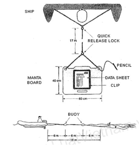
b) Before raising the manta board, one person shall record the weather status (the rain, the sun, the wind, the temperature), the sea surface status, make preliminary description about the survey area, measure the distance from the oil slick;
c) The operator shall start the ship when the observer underwater signals. One person on the ship shall record the time and coordinate of the starting point. Maintain the ship speed at 3-5 km/h;
d) The operator shall stop the ship after 2 minutes from the initial position so that the person underwater shall record the data, and the person on deck shall record the coordinate of the stopping point.
dd) After 2 minutes of pulling, the observer shall record the percentage of living, dead and soft coral coverage in the sheet;
e) The observer must notice the damage by waves, spiny starfish, and giant clams (estimate their quantity in each time);
g) The data of hard, soft and dead coral coverage must be recorded;
h) Data analysis: the data collected shall be imported to EXCEL and demonstrated in graphs or maps.
3.6.3. Reefcheck method
a) Scope of application: this method may apply to all coral reefs longer than 100m with limited visibility that the Manta tow method cannot be implemented;
b) Select survey positions near the places greatly affected by oil slick, avoid steep or rugged coral reefs. It is recommended to select reefs at least 100m length with tolerable inclination to place the transects. Describe the positions and record the necessary data such as longitude and latitude, distance from the shore, distance from the estuary, distance from the oil slick, level of pollution;
c) Execution: place the 100m line transect parallel to the isobaths at 2 - 6m depth, and another line at 6 – 12m depth. Only one line transect at 2 – 6m depth in narrow and shallow reefs. The 100m line transect is divided into 4 segments, each segment is 19.5m length (which means the survey is carry out within the segments from 0 – 19.5m, 25 – 44.5m, 50 – 69.5m, 75 – 94.5m). The distance between the segments is 5m to ensure the reliability during the data calculation of this method. The substrates under the line transect are recorded at 0.5 intervals along the line. Starting at 0m, then 0.5m, 1.0m, 1.5m… up to 19,5m. When reaching 19.5m point, the first segment out of 4 segments of the 100m line transect is done. Skip the 20 - 24.5 segment. The procedure shall be repeated from 25 – 44.5m, 50 – 69.5m, 75 – 94.5m, skip the 20 – 24.5m, 45 – 49.5m, 70 – 74.5m, 95 – 100m segments. The substratum categories are recorded in the data sheet in symbols under the instruction on the substratum category sheet. The ten substratum categories are: hard coral (HC), soft coral (SC), dead coral (DC), rock (RC), rubble (RB), sand (SD), silt/clay (SI), fleshy seaweed (FS), sponge (SP), and other (OR).
3.6.4. Requirements for persons in charge of coral survey: engineers level 5 or above.
3.7. Sea fish
3.7.1. Sampling from coral reefs
a) Quickly assess the fish resources of the coral reef by direct observation combined with submerged photographing:
- Select the survey position: carry out overall survey about the reef (type and layout of). The position selected must represent the entire reef. All positions must by physically similar with the same inclination and coral coverage. Carry out overall survey using the manta tow for clear water, or using point-diving method for turbid water. Select at least 2 points (repeated) towards the wind direction to calculate the change of position in one habitat. Each position in the habitat (the upwind side) must be similar to other points of wind direction. In case the upwind and downwind position are noticeable, then chose at least 1 or 2 positions in each area. Select the points in the reef towards different monsoons in areas of which the monsoons are opposite to the regular ones The distance between the points in a habitats must be appropriate (100 – 200m);
- General techniques: the species must quantitatively prevail that are not nocturnal. They must be easily identified underwater. They must be closely related to the habitats along the reef;
- Placing transects: place at least 2 line transect (50m) at each point on the reef at 3 – 5m depth and 8 – 10m depth. Use the line transects for surveying the seafloor life forms. It is recommended to survey the fish and life forms of the seafloor on the same reef;
- Survey technique: the survey time is 8h30 – 15h30 to ensure the luminance of the sun on the reef, and avoid the counting the nocturnal groups of fish (hunting at night). Wait 5 – 15 minutes after placing the line transects and count after the fish regain their usual habit. Each transect shall form a 50m x 5m belt. The scuba-diving observer shall swim slowly along the transect and record every species of fish seen within 2.5m (density, approximate body length, species) on the two sides and 5m ahead and above the transect. If the visibility is low, the width of the belt transect may be reduced to 2.5m and 2.5m above. b) Method for surveying and assessing the fluctuation of fish resources on Reef Check
- Select the survey positions: select the coral reef depending on the survey target. Select reefs at least 100m length to place the cross sections. Describe the parameters of the positions such as longitude and latitude, distance from the shore, distance from the estuary, distance from the closest residential areas, level of pollution, the reason of the selection;
- Arranging line transects: the usual number of line transects is 2 and parallel to the isobaths, one of the surface of the reef at 3-6m, and one on the slope of the reef at 6-12m. Make sure that the line transects are not floating on the water surface. Use 2 buoys attached to each end of the line transect to mark the position of the line transect. The 100m transect is divided into 4 segments (0 – 20m, 25 – 45m, 50 – 70m and 75 – 95m). each segment is 20 length to ensure the reliability during the data calculation of this method.
- Survey technique: 10 – 15 minutes after the transects are placed (until the water is calm again), the fish observer shall start to observe, swim slowly and start to count the targets listed in the method along the transects within 2.5m to the side of the line transect, 5m ahead and 5m above from the starting point (0m point) to 5m point. Stop at 5m point in 3 minutes and wait until the fish go out of their caves and continue to count the segment 5 - 10m. Stop for 3 minutes and count the segment 10 – 15m and then count the segment 15 – 20m. The procedure shall be repeated for the remaining segments (25 – 45m, 50 – 70m and 75 – 95m), skip the 20 – 25m, 45 – 50m, 70 – 75m and 95 – 100m segments;
c) The data about fish in coral reefs include: Groupers. Snappers, Seetlips, Emperors, Butterflyfishes, Barramundi cod, Bumphead parrotfish, Humpheadfish, Morray eels.
3.7.2. Methods for sampling inshore fish
a) Select the sampling positions that are representative and comparative;
b) Sampling technique: use various kinds of net at the same time to take specimens. The kinds of net depend on the sampling objects and the habitat appropriate for such kinds of net. Along the periphery of the habitats such as mangrove forests, seaweeds, or coral reef, it is recommended to use a barricade net to collect the specimens of the group of fish moving between the habitats. Record the details about the specimens collected (the sampling position (GPS coordinate), the kind of sampling net, the times of pulling, the pulling period);
c) The specimens shall be wrapped in PVC bags and stored in 10% formalin. The specimens must be classified so that the large-sized individuals shall be stored in 20% formalin. Carry out preliminary identification before taking to the laboratory.
3.7.3. Requirements for persons in charge of sea fish survey: engineers level 5 or above.
3.8. Mangroves
3.8.1. Sampling:
a) Select the position for placing transects. Deploy at least 2 transects in the survey area. The transects must reflect the structural characteristics of the local biome. Deploy at least 3 transects perpendicular to the shoreline and across the mangrove population;
b) Divide the transect into areas of low tides, middle tides and high tides to study the structure of the mangrove biome;
c) Classify the kinds of forests depending on the structure of mangrove species;
d) Place 3 quantitative quadrat of the same size randomly along the line transect. Collect quantitative specimens: leaves, flowers, and fruits to identify the scientific names of the species. Collect qualitative specimens: the quantitative quadrat used for determining the density of mangroves must not smaller than 10m x 10m;
dd) The smaller quadrats may be used if the time is not enough, but each quantitative quadrat must contain 40 – 100 individuals in order to ensure the statistical data.
e) Count the number of plants in the quantitative quadrat. Measure the length and diameter of them. Identify the species in the quadrat and calculate the density in the quantitative quadrat.
3.8.2. Preservation and transportation of specimens:
a) The specimens collected shall be soaked in alcohol, then pressed in paper and put into labeled wooden, metal, or plastic boxes and transported to the library;
b) Specimen handling method: the specimens collected are dried (treated with sulphur) at 400C – 1050C after 24 hours.
3.8.3. Specimen analysis: identify the species.
3.8.4. Requirements for persons in charge of mangrove survey: engineers level 4 or above.
4. Data processing
4.1. Targets of analysis
a) The species;
b) The organic matter (density and mass);
4.2. Data adjustment
a) Make the analysis sheet;
b) Data calculation: determine the natural resources, the diversity, similarity, balance, the coverage of mangroves, seaweeds, algae, and coral;
c) Draw graphs and charts using specialized computer software;
d) Draw resources maps using cartography software such as Mapinfo, Arcview, and other equipment.
4.3. Requirements for persons in charge of data processing: engineers level 3 or above.
5. Assessment and handover
a) Inspect the volume of work done, appraise and assess the results of the investigations and surveys;
b) Assess the data collected. Compare the data with the general rules of the survey area;
c) Make reports on the results, sum up and learn experience for later surveys
6. Products submitted
a) The data book about the investigation and survey results of oceanic ecological elements;
b) The maps, graphs and diagrams of oceanic ecology;
c) The summary report and assessment of the results of oceanic ecology surveys.
Chapter 3.
ACCIDENT HANDLING AND PROVISIONS ON LABOR SAFETY
1. Handling accidents
When encountering problems causing dangers to humans and equipmentd during the oceanographical, chemical and environmental surveys in inshore and island areas, it is required to comply with the following contents:
1.1. For survey vehicles:
a) Take shelter when encountering storms, tropical cyclones, or rough sea that may cause dangers to the ship and humans;
b) The problems such as fire, explosion, leaks, and other problems must be rescued and handle on the spot. Immediately notify functional agencies using radio waves If the problem cannot be solved.
1.2. For survey equipment:
a) The technical problems must be immediately solved, or replace using the spare equipment if not.
b) The broken equipment must be taken ashore to repair in order to assure the quality and the work progress.
1.3. For people participating in the survey:
a) People having minor accidents on deck must be given first aid;
b) People having serious accidents must be immediately taken to closest medical establishments ashore.
2. Provisions on labor safety
2.1. The ships participating in the surveys must comply with the current provisions on marine safety.
2.2. The survey equipment must be use safely and properly.
2.3. For people participating in the survey:
a) All technical officers and workers must undergo labor safety courses;
b) Wearing labor protection equipment as prescribed;
c) Do not use alcohol and smoke while working;
d) Do not use other stimulants.
Chapter 4.
IMPLEMENTATION PROVISIONS
1. The Director of the General Department of Vietnam’s Sea and Islands is responsible for guiding, supervising and inspecting the implementation of this Circular.
2. If the observation norms in this Regulation is amended or supplemented, the new documents shall applies.
3. During the course of implementation, the agencies, organizations and individuals are recommended to send feedbacks on the difficulties to the Ministry of Natural Resources and Environment for amendment and supplement./.