Nội dung toàn văn Decision No. 1771/QD-TTg of December 5, 2008, approving the master plan on construction of Chan May-Lang Co economic zone, Thua Thien - Hue province, up to 2025.
|
THE
PRIME MINISTER |
SOCIALIST
REPUBLIC OF VIET NAM |
|
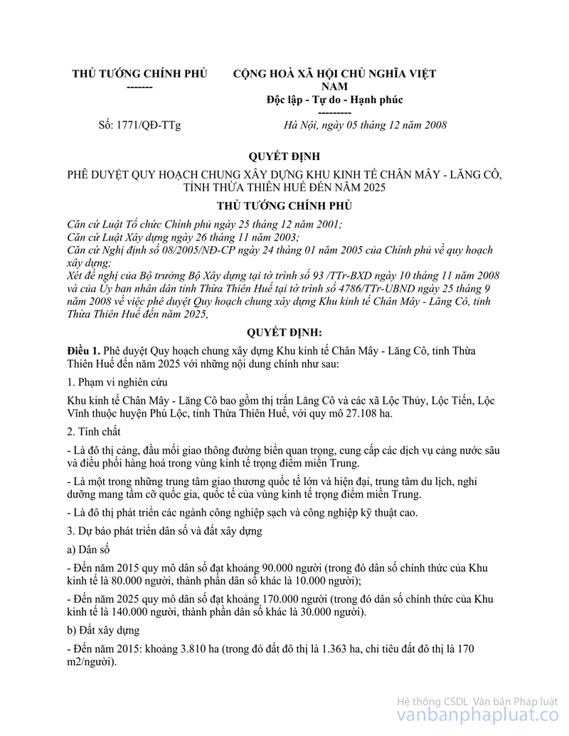
No. 1771/QD-TTg |
Hanoi, December 5, 2008 |
DECISION
APPROVING THE MASTER PLAN ON CONSTRUCTION OF CHAN MAY-LANG CO ECONOMIC ZONE, THUA THIEN - HUE PROVINCE, UP TO 2025
THE PRIME MINISTER
Pursuant to the December 25,
2001 Law on Organization of the Government;
Pursuant to the November 26, 2003 Law on Construction;
Pursuant to the Government's Decree No. 08/ 2005/ND-CP of January 24, 2005, on
construction planning;
At the proposal of the Construction Minister in Report No. 93/TTr-BXD of
November 10,2008, and the People's Committee of Thua Thien - Hue province in
Report No. 4786/TTr-UBND of September 25, 2008, approving the master plan on
construction of Chan May-Lang Co economic zone, Thua Thien - Hue province, up
to 2025,
DECIDES:
Article 1.- To approve the master plan on construction of Chan May - Lang Co economic zone, Thua Thien - Hue province, up to 2025 with the. following principal contents:
1. Scope of study:
Chan May-Lang Co economic zone encompasses Lang Co township and Loc Thuy, Loc Tien and Loc Vinh communes of Phu Loc district, Thua Thien - Hue province, covering an area of 27,108 ha.
2. Characteristics of the economic zone:
- It is a port town and an important sea transport hub which provides deep-water port services and regulates goods circulation in the Central Vietnam key economic region.
- It is one of big and modem international trade hubs and tourist and resort centers of national and international scale in the Central Vietnam key economic region.
- It is an urban center for development of clean industries and hi-tech industries.
3. Population and construction land forecasts a/ Population
- By 2015, the zone's population will be about 90,000 (including 80,000 registered inhabitants in the economic zone and other 10,000 people living in the zone);
- By 2025, the zone's population will be about 170,000 (including 140,000 registered inhabitants and other 30,000 people living in the zone).
b/ Construction land
- By 2015, the construction land area will be about 3,810 ha (including 1,363 ha of urban land with a per-capita construction norm of 170 m2).
- By 2025, the construction land area will be about 9,980 ha (including 3,980 ha of urban land with a per-capita construction norm of 284 m2).
4. Orientations for spatial development
a/ Orientations for spatial development
- In the south: To exploit to the utmost land areas convenient for the construction of urban centers up to the foot of Bach Ma Hai Van mountain to promote links with Da Nang city. The development of the land fund must not affect the landscape and environment.
- In the north: To develop urban residential and service quarters combined with eco-tourism in close association with Tu Hien estuary and Cau Hai lagoon. The area stretching from East Chan May cape to Phu Gia mountain and Bu Lu river will be reserved for the development of ports, port logistic services and clean industries.
- In the east: The area of East Chan May cape and Lang Co area - Lap An lagoon - Hai Van pass will be exploited for the development environmental landscape-related eco-tourism.
- In the west: To develop low-rise residential quarters combined with tourism and industrial and handicraft services.
- The whole area of Gion, Phu Gia and Phuoc Tuong mountains, Voi islet, Hai Van pass, and ecosystems along Bu Lu and Thua Luu rivers, My Van and Lap An lagoon in the economic zone will be zoned off for the strict protection of the natural landscape.
b/Functional quarters
The whole space of the economic zone is planned to consist of urban functional quarters classified under different regulations on spatial management, including quarters which must comply with the master plan and quarters where land areas can be used in a flexible manner.
Specifically:
- Quarters which must comply with the master plan:
+ Chan May port of 370 ha in East Chan May cape, including a general port and a port exclusively reserved for the non-tariff area.
+ A major cargo transshipment and service trade center of 120 ha in the crossroads between National Highway IA and the road to Chan May port.
+ Chan May urban center and major centers, which cover a total area of about 1,545 ha along Bu Lu and Thua Luu rivers and at the foot of Phuoc Tuong mountain, including:
Urban centers of a total area of 1,022 ha and with an estimated population of 120,000-130,000. including new urban centers and upgraded ones.
Urban-level centers and residential quarters on a total area of about 66 ha, including an administrative center of 10-12 ha, a multi-purpose center on a total area of 25-30 ha, covering commercial, financial and information service centers which will be built into modem high-rise architectural complexes; a 5-hectare medical center, consisting of a general hospital and a medical center of 300-500 patient beds, and residential centers on a total area of about 19 ha.
A training center of 65-70 ha adjacent to the non-tariff area, where job training will be provided for port and industrial park development.
Parks and greenery areas on a total area of 198 ha. including a system of parks and greenery strips along rivers and intermingled with urban centers, and a cultural and sports and physical training center of 25-30 ha in the isle of Bu Lu river, consisting of such facilities as stadium, gymnasium, swimming pool and physical training and sports grounds.
Total urban road land will be about 190 ha,
+ The zone for high-class tourism and eco-
tourism service development: To cover about 1,950 ha in the area from Canh Duong estuary, Cu Du to Tu Hien bridge and Lang Co area along Hai Van mountain and Son Tra islet, including Lang Co tourist resort of950 ha, Bai Chuoi tourist resort of 120 ha, Son Cha island tourist resort of 150 ha, Cu Du tourist resort of 360 ha and Canh Duong tourist resort of 270 ha, and other tourist resorts of 100 ha.
+ Tourist resorts combined with urban residential houses: To occupy a total area of about 485 ha located in Lang Co township and areas to the west of Lap An lagoon. Hoi Mit and Hoi Dua. including an area of 135 ha of Lang Co township, 30 ha of Lap An lagoon resettlement area and 320 ha in Hoi Mit and Hoi Dua.
+ Ecological greenery and landscape protection areas, protective forests, greenery strips along national highways and high-voltage power transmission lines: To occupy about 2,190 ha located in mountains such as Hon Voi, Hai Van, Phu Gia, Phuoc Tuong and Gion.
+ Areas for outbound traffic and key technical infrastructure works: To occupy 280 ha. including 120 ha for outbound roads, including a transshipment center, a railway station and an inter-provincial car terminal; and 30 ha for key infrastructure works such as landfills and water treatment stations.
- Areas where land can be used in a flexible manner:
+ The non-tariff area, industrial parks and port logistic centers: To be located in the area stretching from East Chan May cape to Bu Lu river, cover about 1,540 ha, of which the non-tariff area will occupy 3.000 ha and industrial parks and port logistic centers, 540 ha.
+ Industrial and hi-tech industrial urban service areas, tourist service areas and entertainment centers: To occupy a total area of about 1.500 ha in the area from National Highway IA to the foot of Hon Voi mountain. This area will be reserved for the development of prioritized clean and hi-tech industries or urban service centers and entertainment centers.
5. Orientations for development of the technical infrastructure system
a/ Traffic planning orientations - Outbound traffic + Roads:
National Highway 1A: The section running across Lang Co tourist resort will be built and redirected to the west of Lap An lagoon (in the direction of the tourist route along Lap An lagoon), to new Lang Co bridge and connected to the existing National Highway 1A's section running through Hai Van tunnel. This section of National Highway 1A will be built up to grade-1 road standard with a road width of 54 m and tunnels through Phu Gia and Phuoc Tuong mountain passes.
The North - South expressway: The 4-motorlane section running through Chan May-Lang Co economic zone will lap Ho Chi Minh road, with about 20 km from Chan May urban center to the south of Bach Ma mountain range.
To build a road with a crosssection width of 52 m linking the economic zone with the North-South expressway in parallel with the North-South railway.
+ Railways: Not to redirect the existing railway section and ensure a safety corridor of 16 m for the whole section. To build a branch railway to Chan May port. To build new Chan May railway station combined with a major cargo transshipment and service trade center.
+ Waterways:
Chan May port is a general port consisting of a container transshipment port and a port to serve tourism and trade.
From now to 2025: To build ports along East Chan May cape which share the general port and the non-tariff area's port, covering about 150 ha. After 2025, to continue building ports from Canh Duong road to the coastline, with the functions of Chan May general port separated from those of the non-tariff area's port.
- Inbound traffic
+ Chan May area:
Canh Duong coastal road will have its planned width of 52 m unchanged. The section through Chan May port will be built ai two surface course levels. The higher one with a width of 18 m will be reserved for urban and tourist traffic, while the lower one with a width of 65 m will be for cargo transportation from Chan May port to the non-tariff area.
Trunk roads will have a planned width of 30-44 m. Internal roads will have a planned width of 18-24 m. Roads within the cargo transshipment area will be 15-30 m wide.
+ Lang Co area:
Trunk roads: To use the existing National Highway 1A section with a road width of 36 m running along tourist resorts from Phu Gia mountain pass to Hai Van tunnel. A road adjacent to Phu Gia mountain will be 30 m wide. Regional roads will be 22.5 m wide. Internal roads will be 13-16 m wide.
To build electric tramcars for tourist use: A monorail section surrounding Lang Co tourist resort will have 2-3 central stations near traffic hubs and one passenger embarkation/ disembarkation station for every 300 m; a 10 km-long cable-car line for sight-seeing starting from a station on the mountain slope to the southwest of Lap An lagoon, running northward to the tops of Phu Gia mountain pass and Phu Gia mountain and linking to the road to Gion mountain.
- Traffic service works
+ Parking lots: To occupy a total area of 25 ha (by 2025) and 55 ha (beyond 2025). To promote the building of underground parking lots beneath high-rises and parks and greenery areas.
+ Traffic hubs: To build three interchanges to link the outbound road system with trunk roads of Chan May - Lang Co economic zone: an interchange with the Chan May - Canh Duong thoroughfare to new Chan May urban center, an interchange with the road to Chan May pert, and another on the section running through Hai Van tunnel. In addition, to build an interchange linking the North-South expressway with Chan May-Lang Co economic zone.
b/ Ground leveling and water drainage
- In Chan May area:
+ Chan May industrial park and the non-tariff area will have a construction ground level of + 3.3 m. Parks and greenery areas will have a ground level appropriate to surrounding works, depending on each location. Chan May urban center will have a construction ground level of + 3 m. Chan May industrial park to the south of National Highway 1A, the new station and reception center will have a construction ground level of + 4 m + 20 m.
+ This area has three main basins along rivers. In basin 1 covering the non-tariff area and industrial park No. 1, water will be drained by a system of dug canals and Bu Lu river to West Chan May bay through Canh Duong estuary. In basin 2 covering Chan May urban center and industrial parks No. 3 and 4, water will be drained to Thua Luu and Bu Lu rivers to Canh Duong estuary. In basin 3 covering industrial park No. 2 and areas adjacent to the foots of Phu Gia, Da Kep and Gion mountains along Chu Moi river, water will be drained by dug canals to East Chan May bay.
- Lang Co area:
+ The construction base level will be > 2.7 m (higher than the high tide level). To conduct sectional ground leveling of each sand bar to serve each work, balance on-site excavation and embankment, and refrain from leveling too large grounds to harm planted coastal tree lines. To level grounds for building residential areas in a way ensuring a natural drainage slope, make the fullest use of land and encourage people to plant trees to create a beautiful environmental landscape and prevent quicksand.
+ Water in Lang Co area will be drained through sub-basins to Lap An lagoon and the East Sea.
c/ Water supply:
- The daily-life water supply norm will be 180 liters per person per day and die total water supply demand will be 117,000 m3 per day.
- Water supply source: At the first stage from now to 2015: In order to meet the total demand of 60,000 m per day, to continue using Bo Ghe water plant with an output of 6,000 m3 per day and build Loc Thuy water plant with an output of 55,000 m3 per day, of which 25,000 m3 per day will be taken from Thuy Yen and Thuy Cam lakes and 30,000 m3 per day will be unpurified water from Truoi lake. Up to 2025, to increase the output of Loc Thuy water plant to 110,000 m3 per day with water from Thuy Yen and Thuy Cam lakes.
d/ Electricity supply:
- The electricity supply norm will be 300-500W per person for daily life activities, 100-400 kW per hectare for industries, and 50-150 kW per hectare for public utility and services. The total electricity demand will be 258 MW for the first stage and 629 MW for a long term.
- Electricity sources: Electricity for Chan May-Lang Co economic zone will be supplied from the national electricity grid in Central Vietnam through the following major stations: a 500 kV station of Hue (Cau Hai) to be built according to the genera] diagram No. 6; Chan May 200 kV station to be built during 2010-2015 with an initial output of 250 MVA to be increased to 2 x 250 MVA by 2025; and Cau Hai 220 kV station with an output of 220/110 kV - 2 x 250 MVA to be built outside the designed boundaries and supply an additional output to Chan May - Lang Co economic zone through a 110 kV grid.
- 500 kV and 220 kV high-voltage grids: The directions and positions of poles of the national 500 kV and 200 kV transmission lines with appropriate isolation and operation corridors will be kept unchanged. Newly built 110 kV transmission lines will run along the isolation corridors already planned for transmission lines. To redirect and renovate some sections of the existing 110 kV transmission lines in order to have more land for construction.
Medium-voltage grids: Lang Co tourist resort, the non-tariff area and parks and greenery areas along the coast will use electricity supplied from the underground waterproof medium-voltage cable grid. The non-tariff area and other areas may get access to electricity from the overhead medium-voltage grid.
dd/ Urban water drainage and environmental sanitation
- Wastewater drainage planning
+ To build a totally separate wastewater drainage system. Industrial and urban wastewater will be separately collected and treated.
+ The water drainage network will consist of a system of D300-D600 pressure sewers and underwater relay pump stations with wet-type sewage pumps.
+ To build 6 wastewater treatment plants, including wastewater treatment plant No. 1 with a capacity of 25,000 m3 per day on 5 ha and wastewater treatment plant No. 2 with a capacity of 10,000 m3 per day on 2 ha (for die industrial park); wastewater treatment plant No. 3 with a capacity of 15,000 m3 per day on 3 ha (for the tourist resort); wastewater treatment plant No. 4 with a capacity of 5,000 m3 per day on 1 ha and wastewater treatment plant No. 5 with a capacity of 15,000 m3 per day on about 3 ha (for Chan May urban center); and wastewater treatment plant No. 6 with a capacity of 5,000 m3 per day on I hectare.
- Solid waste collection and disposal
To build a solid waste disposal facility to the east of Phuoc Tuong mountain pass in Loc Thuy commune (at present, its feasibility study project is available) with a separate section of 10-20 ha for hazardous waste treatment. For a long term, solid waste will be transported to an inter-provincial solid waste treatment complex (to be located in Huong Tra district under the master plan on construction of the Central Vietnam key economic region).
- Cemeteries: To build Chan May cemetery of 30 ha at the foot of Phuoc Tuong mountain and Truong Dong cemetery of 3.5 ha at the foot of Phu Gia mountain pass. For independent residential areas in Hoi Dua and Hoi Mit areas, separate cemeteries will be built.
e/ Information and communication:
- Circuit-switching system: To develop ODA-funded project HOST in Chan May area to meet the economic zone's information and telecommunications requirements; to upgrade two switchboards into ALCATEL-type 1,000E10MM ones at the initial stage.
- Transmission: A relay system will be designed in the loop-circuit layout to ensure transmission safety. At the initial stage, to build transmission lines along Lang Co, Canh Duong, Tu Hien and Vinh Giang areas connected to transmission cable lines along national highway 1A. To provide such services as television, broadband Internet, videophone, etc.
6. The initial stage of the master plan - up to 2015:
a/ Land use and technical infrastructure planning:
- To invest in building resettlement areas: Loc Vinh resettlement area of 35 ha, Loc Thuy and Loc Tien resettlement areas of 19 ha and Lap An lagoon resettlement area of 30 ha;
- To build industrial parks No. 1.2 and 3 on a total area of 560 ha and the non-tariff area of around 1.000 ha;
- To develop tourist resorts and entertainment centers: Lang Co international eco-tourism and resort of200 ha: Cu Du tourist resort. 300 ha; and Bai Chuoi tourist resort, 100 ha;
- To build functional centers: A health center of 5-6 ha: a training center, 25-70 ha; and a trade, financial, telecommunications, sports and physical training center, 100 ha;
- To develop urban residential areas: To build residential quarters No. 1 and 2 adjacent to general administrative and trade centers;
- To develop an infrastructure system in line with the first-stage land use planning.
b/ Programs and projects prioritized for investment:
Lap An, Loc Vinh, Loc Thuy and Loc Tien resettlement projects;
- Projects on urban centers and infrastructure in Chan May area;
- A project on building the non-tariff area;
Industrial parks No. 1,2 and 3;
- A project on building Loc Thuy water plant with an output of 55,000 m3 per day using water from Thuy Yen and Thuy Cam lakes through the main water pipeline system;
- A project to build wharves No. 2 and 3 and a breakwater dam in Chan May port;
- Projects to build 220 kV and 110 kV transformer stations to serve industrial parks No. 1, 2 and 3, the non-tariff area and Laguna - Hue tourist resort. To increase the capacity of Cau Hai and Lang Co 110 kV stations to 2 x 25 MVA;
- Projects to build wastewater treatment plants No. 1,2,4 and 5, garbage collection and disposal facilities, and Chan May cemetery;
- Projects to build new Chan May railway station and Chan May inter-provincial car terminal;
- A project to build a road seed on linking Chan May-Lang Co with the North-South expressway (the section running through the economic zone).
Article 2.- Organization of implementation
1. The Construction
Ministry shall direct and guide the People's Committee of Thua Thien -Hue
province in organizing the implementation
of the master plan under this Decision.
2. The People's Committee of Thua Thien-Hue province shall:
a/ Publicize the master plan on construction of Chan May-Lang Co economic zone up to 2025, so that concerned organizations and individuals can know and implement it; organize the implementation of the master plan under current law.
b/ Promulgate the Regulation on management of the master plan on construction of Chan May-Lang Co economic zone.
c/ Organize the elaboration and approval of detailed plans on functional urban quarters and adjustment of approved detailed plans to make them in line with the approved master plan.
d/ Coordinate with the Transport Ministry in determining directions and sizes of outbound traffic works in Chan May-Lang Co economic zone.
3. The Planning and Investment Ministry and the Finance Ministry shall balance and allocate annual capital amounts under the State Budget Law for implementation of this master plan.
Article 3.- This Decision takes effect on the date of its signing.
The president of the People's Committee of Thua Thien - Hue province, the Construction Minister, other ministers, heads of ministerial-level agencies and government-attached agencies, and concerned organizations and individuals shall implement this Decision.
|
|
PRIME
MINISTER |