Nội dung toàn văn Decision No.46/2014/QD-TTg providing for natural disaster forecasting warning and communication
|
THE
PRIME MINISTER |
SOCIALIST
REPUBLIC OF VIETNAM |
|
No. 46/2014/QD-TTg |
Hanoi, 15 August, 2014 |
DECISION
PROVIDING FOR NATURAL DISASTER FORECASTING, WARNING AND COMMUNICATION
Pursuant to the Law on organization of Government dated 25 December, 2001;
Pursuant to the Law on natural disaster prevention and control dated 19 June 2013;
Pursuant to Decree No. 66/2014/ND-CP dated 04 July 2014 detailing and guiding the implementation of a number of articles of the Law on natural disaster prevention and control;
At the request of the Minister of Natural Resources and Environment,
The Prime Minister issues the Decision providing for natural disaster forecasting, warning and communication.
Chapter I
GENERAL PROVISIONS
Article 1. Scope of regulation
This Decision provides for natural disaster forecasting, warning and communication in service of prevention, response and remedy of natural disasters in Vietnam.
Article 2. Subjects of application
This Decision applies to the Ministries, sectors and localities, organizations and individuals engaged in natural disaster forecasting, warning and communication; organizations, households and individuals having activities related to the natural disaster forecasting, warning and communication.
Article 3. Types of natural disasters for forecasting, warning and communication
1. Storms and tropical depression operating in the West waters of longitude 120° E, North waters of latitude 05° N and South waters of latitude 23° North (hereafter referred to as East Sea, Annex I of this Decision) and on the inland of the territory of Vietnam.
2. Storms and tropical depression operating outside the East Sea but possibly moving into the East Sea within the next 24 to 48 hours.
3. Floods on the rivers in the territory of Vietnam and related inter-national rivers (Annex II and III of this Decision).
4. Earthquakes with magnitude (M) of equal or greater than 3.5 (on Richter scale or the equivalent) can affect Vietnam.
5. Earthquakes with magnitude (M) of greater than 6.5 (on Richter scale or the equivalent) occurring in the sea possibly causing tsunami which can affect Vietnam.
6. Tsunamis occurring from the earthquakes in offshore waters possibly affect Vietnam.
7. Natural disasters such as whirlwinds, lightning, heavy rain, flash floods, floods, landslides due to torrential rain or flow, land subsidence caused by torrential rain, surge, salinity intrusion, heat wave, drought, damaging cold, hail, frost and other natural disasters.
Article 4. Explanation of concepts and terms used in the Decision
1. Tropical cyclone is the cyclone area (diameter can be hundreds of kilometer) formed in tropical sea. The wind whirls to the center in the counterclockwise direction. The atmospheric pressure in the tropical cyclone is lower than the surrounding area with rain and sometimes accompanied with thunderstorm and whirlwind.
2. Tropical cyclone center is an area with lowest atmospheric pressure value in the tropical cyclone as the contingence of whirlwind blowing in from the surrounding area.
3. The strongest wind force in the tropical cyclone is the greatest average speed of wind determined in two (02) minutes of observation (with Beaufort scale, Annex IV of this Decision).
4. Gust is the wind with speed increased immediately and determined within two (02) seconds
5. Tropical depression is a tropical cyclone with the strongest wind force from level 6 to level 7 and possible gust (Annex IV of this Decision).
6. Storm is a tropical cyclone with the strongest wind force from level 8 or above and possible gust. Storm with strongest wind force from level 10 to 11 is called strong storm, from level 12 to 15 is very strong storm, from level 16 or above is a hurricane (Annex IV of this Decision).
7. Storm or tropical depression landfall is when the center of storm or low depression moves over land.
8. Storm or tropical depression abatement is when the storm or tropical depression weakens into a low-pressure area with the strongest power force of less than level 6.
9. Strong wind area caused by circulation of storm or tropical depression is the area with strong swirling wind from level 6 or abo vùng có gió xoáy mạnh từ cấp 6 trở lên.
10. Area directly affected by the storm or tropical depression is the area with bad weather, rain and strong wind from level 6 or above caused by storm or tropical depression.
11. Error of storm forecasting is the difference of forecast storm center and actual storm center, between the forecast strongest wind force and actual strongest wind force at the time of forecasting.
12. Surge due to storm is a phenomenon where the seawater rises higher than the normal tide due to storm.
13. Whirlwind is a vortex with the wind force equivalently strong to that of storm but formed and abated in a short time, its operating range is narrow from a few to a few tens of km2
14. Lightning is a discharge phenomenon in the cloud, between clouds or between cloud and ground.
15. Heavy rain is a phenomenon of rain the total rainfall of which reaches over 50 mm in 24 hours. The total rainfall from 51 mm to 100 mm in 24 hours is heavy rain or very heavy rain in case of over 100 mm.
16. Flash flood is the flood suddenly occurring on small basins of river or streams in the mountainous area with accelerated flow often accompanied with debris. The flood rises up and down fast with major damage.
17. Flooding is a phenomenon in which the ground is flooded due to heavy rain, flood, high tide and seawater surge.
18. Landslide is a phenomenon in which the land falls down, slides or collapses due to rain, flood or flow.
19. Land subsidence is a phenomenon in which the land slips lower than that of surrounding area due to rain, flood or flow.
20. Salinity intrusion is a phenomenon in which the salty water with the saline concentration equal to 4 ‰ intrudes into the interior field upon occurrence of high tide, sea level rise or depletion of freshwater resources.
21. Heat wave is a special form of weather in summer and occurs when the highest air temperature during the day exceeds 35oc and air humidity is below 65%.
22. Drought is a phenomenon of serious water shortage which occurs for a long time due to lack of rain and depletion of water resources.
23. Damaging cold is a special weather occurring in winter in the North of Vietnam when the average air temperature during days is below 13oC
24. Hail is the rain in the form of ice balls or pieces with different sizes and shapes and occurs during a short time accompanied with rain and strong wind occasionally..
25. Hoar frost is a phenomenon in which the vapor freezes into white small pieces like salt on the ground or surface of trees or other objects. Hoarfrost is usually formed in the winter night, windless and cloudless sky during the early months of winter in the North of Vietnam.
26. Flood is a phenomenon where the river water level rises high within a certain period of time and goes down. Flood is classified into the following types:
a) Minor flood is the one with flood peak lower than the average flood peak of years
b) Moderate flood is the one with flood peak equivalent to the average flood peak of years
c) Major flood is the one with flood peak higher than the average flood peak of years
d) Particularly large flood is the one with flood peak rarely seen in the observation periods.
dd) Historic flood is the one with the highest flood peak in the observation or survey data sequence
27. Unusual flood is the one occurring before or after flooding season specified in Clause 32 of this Article or formed from water discharge from reservoir, due to dam failure, overflow or dike break.
28. Flood peak is the highest water level in a flood at a measuring path. Annual flood peak is the highest one observed in a year. Average flood peak of years is the average numeric value of annual flood peak during observation period.
29. Amplitude of flood is the numeric value of water level difference between the water level and the one right before the flood rise.
30. Flood intensity is the numeric value of variation of water level of flood in a unit time.
31. Flood forecasting error is the difference in water level or forecast water flow compared with the actual value at the time of forecast.
32. Flooding season is a constant time in a year in which flood usually occurs and is determined as follows:
a) On the rivers of the North, from 15 June to 15 October;
b) On the rivers from Thanh Hoa province to Ha Tinh province, from 15 July to 15 November;
c) On the rivers from Quang Binh province to Ninh Thuan province, from 01 September to 15 December.
d) On the rivers in Binh Thuan province and provinces of the South and Central Highlands, from 15 June to 30 November.
33. Natural disaster risk is the damages which can be caused by natural disaster of people, properties, living conditions and social-economic activities.
34. Level of natural disaster risk is a classification of damages which can be caused by natural disaster of people, properties, living conditions and social-economic activities.
35. State of emergency of natural disaster is a situation in which the types of natural disaster specified in Article 3 of this Decision are at the natural disaster risk of level 5, which can cause disaster and heavy losses of life, properties, infrastructure and ecological environment.
36. Tsunami is long-period series of waves (from a few minutes to hours) spreading at high speed (up to 800 km/h). When reaching the shore, depending on the depth of sea and coastal topography, tsunami can reach the height of tens of meter and overflow to the inland causing disaster.
Earthquakes, volcanic eruptions and other underwater explosions (including underwater nuclear tests), landslides, meteorite collisions, ... occurring at sea likely cause tsunami. The map of the sources of earthquakes which can cause tsunami affecting Vietnam is shown in Annex XII of this Decision.
37. Areas directly affected by the tsunami are coastal shallow waters and lands within the range to which the tsunami may spread. Depending on the topographical height, tsunami can directly affect the inland when moving kilometers from the coast.
38. Earthquake is the ground vibration as the result of a sudden release of energy in the Earth's crust in the form of seismic waves causing distortion of land surface and damaging houses, works, properties and human lives.
39. Hypocenter is the place where the earthquakes occur.
40. Earthquake epicenter is a vertical projection of hypocenter on the earth surface.
41. Depth of hypocenter is a distance from the hypocenter to the epicenter.
42. Seismic intensity on the surface (I) is a quantity denoting the vibratility caused by an earthquake on the land surface and is assessed by the extent of its impact on housing, works, ground, objects and people. In this Decision, the vibration intensity on the surface is assessed by MSK-64 scale including 12 degrees (Appendix IX of this Decision).
The relation between the earthquake magnitude, types of earthquake, seismic intensity, impact and annual occurrence frequency in the world is specified in Annex X. The seismic zoning map in the territory of Vietnam and vicinity is shown i Annex XI of this Decision.
43. Earthquake magnitude (M) is the quantity characterizing the energy which the earthquake releases and transmits to the surrounding space in the form of elastic waves. In this Decision, the moment magnitude scale is used for earthquake magnitude. The earthquake is classified into the types: Micro earthquake (M<2.0), small="" earthquake="">£M£3,9), minor earthquake (4,0£M£4,9), moderate earthquake (5,0£M£5,9), major/large earthquake (6,0£M£6,9), great earthquake (7,0£M£7,9) and macro earthquake (M³8,0).
Article 5. Agencies and organizations responsible for broadcasting of newscasts of natural disaster forecasting and warning
1. Ministry of Natural Resources and Environment
a) National Centre for Hydrometeorological Forecasting directly under the National Centre for Hydrometeorological Forecasting is responsible for issuing the newscasts of forescasting and warning of storms, tropical depressions, floods and other types of natural disaster specified in Clause 7, Article 3 of this Decision nationwide;
b) Regional and provincial hydro-meteorological stations directly under the National Centre for Hydrometeorological Forecasting are responsible for issuing the newscasts of forescasting and warning of floods on the rivers specified in Annex III and types of natural disaster specified in Clause 7, Article 3 of this Decision within their areas and provinces.
2. Vietnam Academy of Science and Technology
The Institute of Geophysics under the Vietnam Academy of Science and Technology is responsible for issuing the forescasting and warning newscasts of tsunami specified in Clause 4, 5 and 6, Article 3 of this Decision.
Article 6. Use of newscasts of forescasting and warning of natural disasters
1. The newscasts of forescasting and warning of natural disasters broadcast by the agency or organization specified in Article 5 are the official ones, which are used in directing and managing the prevention, response and remedy of consequences of natural disasters in Vietnam.
2. Regional and provincial hydro-meteorological stations are responsible for detailing the newscasts of forescasting and warning of natural disasters broadcast by the National Centre for Hydrometeorological Forecasting in accordance with the requirements for prevention, response and remedy of consequences of natural disasters at localities.
Article 7. Agencies and organizations responsible for transmitting forescasting and warning newscasts of natural disasters
1. Vietnam Television, Voice of Vietnam.
2. Broadcasting stations and television stations of provinces and centrally-run cities.
3. Agencies managing the communication system on natural disasters
Chapter II
FORECASTING AND WARNING OF NATURAL DISASTERS
Section 1. FORECASTING AND WARNING OF TROPICAL DEPRESSION
Article 8. Broadcasting of newscasts of forecasting and warning of tropical depression
1. Newscast of tropical depression near East Sea
The newscast of tropical depression near East Sea is broadcast when the tropical depression operates outside the East Sea and likely moves into the East Sea within the next 24 to 48 hours.
2. Newscast of tropical depression in the East Sea
The newscast of tropical depression in the East Sea is broadcast when the tropical depression operates in the East Sea and has one of the following conditions:
a) The place of tropical depression center is over 500 km away from the nearest point of Vietnam’s inland coast;
b) The place of tropical depression center is from 300 to 500 km away from the nearest point of Vietnam’s inland coast and the tropical depression is unlikely to move to the inland of Vietnam within the next 24 hours.
3. Newscast of nearshore tropical depression
Newscast of nearshore tropical depression is broadcast with one of the following conditions:
a) The place of tropical depression center is under 300 km away from the nearest point of Vietnam’s inland.
b) The place of tropical depression center is from 300 to 500 km away from the nearest point of Vietnam’s inland coast and the tropical depression is likely to move to the inland of Vietnam within the next 24 hours.
4. Newscast of tropical depression in the inland
The newscast of tropical depression in the inland is broadcast with one of the following conditions:
a) The tropical depression center has hit the inland;
b) The storm has hit the inland and weakened into tropical depression.
5. Last newscast of tropical depression
The last newscast of tropical depression is broadcast when the tropical depression is over.
Article 9. Broadcasting of newscasts of forecasting and warning of storms
1. Newscast of storm near the East Sea
The newscast of the East Sea is broadcast when the storm operates outside the East Sea and is likely to move into the East Sea within the next 48 hours.
2. Newscast of storm in the East Sea
The newscast of storm in the East Sea is broadcast when the storm operates in the East Sea with one of the following conditions:
a) The place of the eye of the storm is over 1,000 km away from the nearest point of Vietnam’s inland coast.
b) The place of the eye of the storm is from 500 to 1,000 km away from the nearest point of Vietnam’s inland coast and the storm is not likely to move to the inland of Vietnam within the next 48 hours.
3. Newscast of nearshore storm
The newscast of nearshore storm is broadcast when there is one of the following conditions:
a) The place of the eye of the storm is from 500 to 1,000 km away from the nearest point of Vietnam’s inland coast and the storm is likely to move to the inland of Vietnam within the next 48 hours.
b) The place of the eye of the storm is from 300 to less than 500 km away from the nearest point of Vietnam’s inland coast and the storm is not likely to move to the inland of Vietnam within the next 48 hours.
4. Newscasts of emergency storms
The newscast of emergency storm is broadcast when there is one of the following conditions:
a) The place of the eye of the storm is less than 300 km away from the nearest point of Vietnam’s inland coast.
b) The place of the eye of the storm is from 300 to 500 km away from the nearest point of Vietnam’s inland coast and the storm is likely to move to the inland of Vietnam within the next 48 hours.
5. Newscast of storm in inland
The newscast of storm in inland is broadcast when there is one of the following conditions:
a) The eye of the storm has hit the inland of Vietnam and the strongest wind force still remains from level 8 or higher;
b) The eye of the storm has hit other countries but the strongest wind force still remains from level 8 or higher and possibly affects Vietnam directly within the next 48 hours.
6. Last newscast of eye of the storm
The last newscast of eye of the storm is broadcast when there is one of the following conditions:
a) The storm is over;
b) The storm has hit other countries or moved out of Vietnam’s territory and no longer affects Vietnam directly.
c) The storm has moved outside the East Sea and is not likely to move back to Vietnam.
Article 10. Contents of forecasting and warning newscast of tropical depression
1. Title of newscast of tropical depression: is written under the provisions of Article 8 of this Decision.
2. Brief newscast of state of tropical depression at the most recent time.
a) The development during the last 24 hours;
b) The time: Newscasts are given according to the round time or local time of Hanoi;
c) The place of tropical depression center: Identified by the coordinate of longitude and latitude with the accuracy up to 1/10; in case the tropical depression center can not be identified at a point of coordinate, it shall be identified in a square, each side is equal to one (01) degree of longitude or latitude
d) The nearest distance from the place of tropical depression center to one of the locations: island or archipelago in the East Sea, a specific place name in the inland of Vietnam or surrounding country.
dd) The intensity of tropical depression: Warn with Beaufort scale for strongest wind and gust in tropical depression;
c) The movemet direction of tropical depression: Identified by one of 16 directions: North, North Northeast, Northeast, East Northeast, East, East Southeast, Southeast, South Southeast, South, South Southwest, Southwest, West, West Northwest, Northwest, North Northwest;
g) Movement speed: Warn by km / h;
h) When the tropical depression has direct impact on the islands and inland, the data observed at the stations in the affected areas should be provided.
3. Forecasting of developmet of tropical depression in the next 24 hours
a) Forecasting of direction and movement speed of tropical depression;
b) Forecasting place of tropical depression;
c) The nearest distance from the tropical depression center to one of the locations: island or archipelago in the East Sea, a specific place name in the inland of Vietnam or surrounding country.
d) Development of intensity of tropical depression;
dd) Map of forecasting of line of motion of tropical depression, strong wind radius and error or a circle with probability of 70% to which the tropical depression center is likely to move in.
4. Forecasting of effect of tropical depression
a) For newscast of tropical depression near the East Sea: Forecasting of time of movement to the East Sea of the tropical depression and its impact on waters, island or archipalego and possibility of causing strong winds and high waves
b) For newscast of tropical depression in the East Sea: Forecasting of impact of tropical depression on waters, island or archipalego and the possibility of causing strong winds and high waves
c) For newscast of nearshore tropical depression: Forecasting of areas directly affected by the tropical depression, expected time and landing area of the tropical depression, incidence of strong wind of level 6-7, heavy rain, wave height, possible sea level rise and other types of natural disaster in the next 12-24 hours.
d) For the newscast of tropical depression in the inland and the last newscast of tropical depression: forecasting of areas directly affected by the tropical depression, possibility of heavy rain and other natural disasters.
5. The levels of natural disaster risk due to tropical depression are specified by the Prime Minister.
6. Time of issuing the subsequent newscasts.
Article 11. Contents of forecasting and warning newscast
1. Title of storm: is written under the provisions of Article 9 of this Decision together with the number of storm which is determined in order of storms operating in the East Sea in a year. Do not set the numbers of the storms operating near the East Sea.
2. Brief information on state of storm at the most recent time
a) The development during the last 24 hours;
b) The time: Newscasts are given according to the round time or local time of Hanoi;
c) The place of eye of the storm: Determined by the coordinate of longitude and latitude with the accuracy up to 1/10 degrees;
d) The nearest distance from the place of eye of the storm to one of the locations: island or archipelago in the East Sea, a specific place name in the inland of Vietnam or surrounding country.
dd) Storm intensity: Warn with Beaufort scale for strongest wind and gust in the storm.
e) The movemet direction of storm: Identified by one of 16 directions: North, North Northeast, Northeast, East Northeast, East, East Southeast, Southeast, South Southeast, South, South Southwest, Southwest, West, West Northwest, Northwest, North Northwest;
g) Movement speed: Warn by km / h;
h) When the storm has direct impact on the islands and inland, the data observed at the stations in the affected areas should be provided.
3. Forecasting of developmet of storm
a) The developmet of storm in the next 24 and 48 hours with the factors specified in Clause 2 of this Article;
b) Warning of direction, speed of movement and intensity of storm in the next 48 and 72 hours;
c) Map of forecasting of line of motion of storm, strong wind radius and error or a circle with probability of 70% to which the tropical depression center is likely to move in.
4. Forecasting of effect of tropical depression
a) For newscast of storm near the East Sea: Forecasting of time of movement to the East Sea of the storm and impact of storm circulation on waters, island or archipalego and possibility of causing strong winds and high waves
b) For newscast of storm in the East Sea: Forecasting of impact of storm circulation on waters, island or archipalego and the possibility of causing strong winds and high waves; specific information on incidence of strong storm wind, high waves and state of sea in the next 24 – 48 hours and warning of the next 72 hours.
c) For newscast of nearshore tropical depression: Forecasting of impact of storm circulation on the waters, islands and archipelago, expected time and landing area of the tropical depression, incidence of strong wind of level 6-7, heavy rain, wave height, possible sea level rise and other types of natural disaster in the next 12-24 hours.
d) For newscasts of emergency storm: Forecasting of impact of storm circulation on the waters, islands and archipelago, expected time and landing area of the storm, incidence of strong storm wind, heavy rain, wave height, possible sea level rise and other types of natural disaster in the next 12-24 hours.
dd) For the newscast of storm in the inland and the last newscast of storm: forecasting of areas directly affected by the storm, forecasting and warning of heavy rain and other natural disasters.
5. The levels of natural disaster risk due to storms are specified by the Prime Minister.
6. Time of issuing the subsequent newscasts.
Article 12. Frequency and time of issuing newscasts of forecasting and warning of tropical depression and storms
1. Newscasts of tropical depression near the East Sea: Issue 03 newscasts at 9:00 am, 14:30 pm and 21:00 pm.
2. Newscast of storms near the East Sea and tropical depression in the East Sea.
a) Broadcasting of 04 main newscasts at 2:30 am, 9:00 am, 14:30 pm and 21:00 pm.
b) In case of complex development of tropical depression in the East Sea, in addition to the 04 main newscasts, it is necessary to issue additional newscasts interspersed between the main ones.
3. Newscasts of nearshore tropical depression and in the inland, storm in the East Sea, nearshore storms, emergency storms and inland storms.
a) Broadcasting of 08 main newscasts at 2:30 am, 5:00 am, 9:00 am, 11:00 am, 14:30 pm, 17:00 pm, 21:00 pm and 23:00 pm;
b) In case of newscasts of nearshore tropical depression or emergency storms and complex development of tropical depressions and storms, in addition to the 08 main newscasts, it is necessary to issue additional newscasts interspersed between the main ones.
Section 2: FORECASTING AND WARNING OF FLOOD
Article 13. Broadcasting of newscasts of forecasting and floods
1. Newscasts of warning of floods
Newscasts of warning of floods are broadcast upon detection of heavy or so heavy rains which possibly cause floods, the water level in the rivers can reach to the alarm level II or occurrence of extraordinary floods.
2. Newscasts of floods
Newscasts of floods are broadcast when the water level on rivers reach to the alarm level II and continue to rise, or when the water level of rivers is down but still higher than the alarm level II.
3. Newscasts of emergency floods
Newscasts of emergency floods are broadcast when the water level on rivers reach to the alarm level III and continue to rise, or when the water level of rivers is down but still higher than the alarm level III.
Article 14. Contents of newscasts of forecasting and warning of floods
1. Newscasts of warning of floods
a) Title of newscast of warning of flood together with name of river and location of flood is specified in Annex II and III of this Decision.
b) Characteristics of rain in the basin.
c) Are of possible occurrence of flood;
d) Alarm level of possible occurrence of flood;
dd) Time of issuing the subsequent newscasts.
2. Newscasts of flood and emergency flood
a) Title of newscast of flood and emergency flood together with name of river and location of flood is specified in Annex II and III of this Decision.
b) State of development of flood during the last 24 hours and data of water level actually measured at the most recent time.
c) Possibility and development of flood during the expected time;
d) Forecast water level of the flood and forecast water level compared with the water level of alarm levels or the water level of flood peak in particularly large floods or historic floods;
dd) The levels of natural disaster risk due to floods are specified by the Prime Minister.
e) Time of issuing the subsequent newscasts.
Article 15. Frequency and time of issuing newscasts of forecasting and warning of floods
1. The newscasts are broadcast when the water level in the rivers can reach to the alarm level II or occurrence of extraordinary floods.
2. Newscasts of floods
a) Floods on Red and Thai Binh rivers, issue 02 newscasts/day at 9:30 am, 17:30 pm. In case of complex development of floods, it is necessary to issue an additional newscast at 21:30 pm;
b) Floods on Tien and Hau rivers, issue 1 newscast/3 days at 9:30 am;
c) Floods on other rivers, issue 03 newscasts/1 day at 9:30 am, 17:30 pm and 21:30 pm.
3. Newscasts of emergency flood
a) Floods on Red and Thai Binh rivers: issue 03 main newscasts at 9:30 am, 17:30 pm and 21:30. In case of complex development of flood, in addition to 03 main newscasts, it is necessary to issue additional newscasts interspersed between the main ones.
b) Floods on Tien and Hau rivers, issue 1 newscast/2 days at 9:30 am. In case of complex development of flood, it is necessary to issue additional newscasts interspersed between the main ones.
c) Floods on other rivers, issue 04 main newscasts/day at 5:30 am, 9:30 am, 17:30 pm and 21:30 pm. In case of complex development of flood, it is necessary to issue additional newscasts interspersed between the main ones.
Article 16. Forecasting and warning of floods on local river systems
1. The forecasting and warning of floods on local river systems (specified in Annex III) shall comply with the provisions of Article 13 and 14 of this Decision.
2. The agency issuing the newscasts of forecasting and warning of floods as prescribed in the provisions in Clause 1 of this Article, based on the requirements of flood prevention and control and characteristics of each river or local river system, shall make a decision on the time and frequency of issuing the newscasts of forecasting and warning of floods.
Section 2: INFORMATION ABOUT EARTHQUAKE AND WARNING OF TSUNAMI
Article 17. Broadcasting of newscast of earthquake
The newscast of earthquake is broadcast when:
1. There are earthquakes with their magnitude (M) equal to or greater than 3.5 (on Richter scale or equivalent) possibly affecting Vietnam.
2. The earthquakes with their magnitude of greater 6,5 (on Richter scale or equivalent) occurring at sea possibly cause tsunamis affecting Vietnam.
Article 18. Contents of earthquake newscast
1. Title of earthquake newscast
2. Time of occurrence of earthquake: Newscasts are given according to GMT or local time of Hanoi
3. Location of earthquake: Name of locality, coordinate of epicenter and depth of hypocenter.
4. Earthquake magnitude of and seismic intensity in the epicenter area and the surrounding localities: Newscasts are given according to MSK-64 scale.
5. Possible consequences of earthquake.
6. The levels of natural disaster risk due to earthquakes are provided for by the Prime Minister.
Article 19. Broadcasting of newscast of tsunami
Newscasts of warning of tsunami are broadcast when:
1. The earthquakes with their magnitude of greater 6,5 (on Richter scale or equivalent) occurring at sea possibly cause tsunamis affecting Vietnam.
2. The tsunamis occur due to earthquake in the offshore waters possibly affecting Vietnam.
Article 20. Newscasts of warning of tsunami
1. The newscasts of warning of tsunami is broadcast with 03 levels:
a) Level 1: Strong earthquake occurs possibly causing tsunami. To be ready for evacuation is recommended.
b) Level 2: Tsunami occurs without destruction but precautions of damages along coastal areas due to should be taken. To be ready for evacuation is recommended.
c) Level 3: Tsunami occurs with destruction. Evacuation is done immediately.
2. Cancellation newscast of tsunami
The cancellation newscast of tsunami is broadcast when the tsunami has not occurred as warned.
3. Last newscast of tsunami.
The last newscast of tsunami is broadcast when the tsunami is completely over.
Article 21. Contents of newscast of warning of tsunami
1. Title of newscast of warning of tsunami is specified in Clause 1. Article 20 of this Decision.
2. Comments on tsunami
a) Place, time, magnitude, coordinate of epicenter and depth of hypocenter of the earthquake;
b) Possible occurrence of tsunami, dangerous levels and areas directly affected by the tsunami;
c) Height of tsunami on the coast and time of impact.
3. Evacuation is required depending on the warning level of newscast.
4. The levels of natural disaster risk due to tsunami are specified by the Prime Minister.
Section 4: FORECASTING AND WARNING OF OTHER TYPES OF NATURAL DISASTER RELATED TO METEOROLOGY, HYDROLOGY AND OCEANOGRAPHY
Article 22. Forecasting and warning of other types of natural disaster related to meteorology, hydrology and oceanography
1. Issuing newscasts of forecasting of other types of natural disaster related to meteorology, hydrology and oceanography whose intensity, dangerous levels, range, possible time of occurrence and levels of risk of natural disaster can be determined, including: Heavy rain, strong wind, flood, surge, salinity intrusion, heat wave, drought, damaging cold, hail, frost.
2. Issuing newscasts of forecasting of other types of natural disaster related to meteorology, hydrology whose intensity, dangerous levels, levels of risk of natural disaster can be determined but their range and time of possible occurrence, including flash floods, thunderstorm, whirlwind, lightining, hail, landslide, land subsidence due to torrential rain or flow
3. Newscasts of forecasting and warning of other types of natural disaster related to the meteorology, hydrology and oceanography can be compiled into separate newscasts or integrated in the newscasts of weather forecast or forecasting and warning of tropical depression, storms and floods.
Article 23. Contents, form, time and frequency of issuing newscasts of forecasting and warning of other types of natural disasters related to meteorology, hydrology and oceanography
Based on the characteristics and nature of each type of natural disaster specified in Clause 1. 2. Article 22 of this Decision, the agency forecasting and warning natural disasters shall issue the newscasts with their contents, form, time and frequency in accordance with each specific case.
Chapter III
INFORMATION ON NATURAL DISASTER
Article 24. Provision of newscast of natural disasters
1. Agencies and organizations issuing the newscasts of forecasting and warning of natural disaster specified in Article 5 of this Decision are responsible for providing the newscasts for the state agencies, the Ministries, sectors, localities and organizations related to the prevention, response and remedy of consequences of natural disasters and the agencies and organizations providing newscast of natural disasters.
2. The list of agencies and organizations provided with newscasts of forecasting and warning of natural disasters is specified in Annex V of this Decision.
Article 25. Time and way to provide newscasts of natural disasters
1. The agencies providing newscasts of natural disasters specified in Clause 1. Article 24 are responsible for providing the newscasts for the agencies specified in Annex V of this Decision within 15 minutes from the time of completion of last newscast of forecasting and warning.
2. The Institute of Geophysics under the Vietnam Academy of Science and Technology must provide the last newscast of forecasting and warning of tsunami right after its completion for the agencies specified in Annex V of this Decision.
3. Way to provide newscasts of natural disasters
a) Public information systems, including telephone and fax systems, central and local television and broadcasting, Internet; postal services in the public postal network, postal network in service of agencies of the Party, State, national defense and security;
b) Special use communication system, including the hotline system for directing and steering the prevention and control of natural disaster, the special use communication and broadcasting system of the Ministries, ministerial agencies or government-attached agencies, the communication system of border guard, the system of tsunami warning communication combined with other warning, the communication services system for the prevention of natural disasters of telecommunication enterprises.
Article 26. Regulation on transmitting newcasts of tropical depression, floods and storms
1. For the Voice of Vietnam
a) When receiving newcasts of tropical depression and storm near or in the East Sea, newscast of warning of flood and newscast of flood, it must issue the newscast for every two (02) hours in the early hours and continuously throughout the day and night on its broadcasting systems. In case of not having received the new newscast, it should re-issue the last newscast.
b) When receiving the newscast of nearshore or inland tropical depression, newscast of nearshore, emergency or inland storm and newscast of emergency flood, it should issue the newscast for two (02) consecutive times immediately, then re-issue one time in the early hours and continuously throughout the day and night on its broadcasting systems or upon requirement for changing the time of broadcasting of newscast from the Ministry of Natural Resources and Environment;
c) When re-issuing the old newcast, it should recall the time of broadcasting of newscast.
2. For Vietnam Television
a) When receiving newcasts of tropical depression and storm near or in the East Sea, newscast of warning of flood and newscast of flood, it must issue the newscast on the latest news program on its channels and re-issue one time for every two (02) hours until there is new newscast or upon requirement for changing the time of broadcasting of newscast from the Ministry of Natural Resources and Environment;
b) When receiving the newscast of nearshore or inland tropical depression, newscast of nearshore, emergency or inland storm and newscast of emergency flood, it should issue the newscast for two (02) consecutive times immediately on its channels, then re-issue one (01) time for every one (01) hour until there is new newscast or upon requirement for changing the time of broadcasting of newscast from the Ministry of Natural Resources and Environment;
c) When re-issuing the old newcast, it should recall the time of broadcasting of newscast.
d) When issuing newscast of natural disaster, in addition to reading the newscast verbatim, it must run the words on the screen to give a brief summary of basic content of the newscast.
3. For Vietnam Coastal Radio Station System
a) When receiving the newscast of tropical depression near or in the East Sea, the newscast of nearshore or inland tropical depression, the newscast of storm near or in the East Sea, the newscast of nearshore, emergency or inland storm, it must issue 132 times/day, in which:
- 96 times are broadcast per day on channel of frequency 7906 KHz
- 36 times are broadcast per day on channel of frequency 8294 KHz
b) When re-issuing the old newcast, it should recall the time of broadcasting of newscast.
Article 27. Regulation on transmitting newcasts of earthquake and warning of tsunami
1. For the Voice of Vietnam and the Vietnam Television
a) Newscast of earthquake is transmitted and broadcast one time right after it is received and re-broadcast in the latest news program.
b) Newscast of warning of tsunami of level 1 and level 2 is transmitted and broadcast right after they receive and re-issue it 02 times, each time is 05 minutes apart. Then re-issue the broadcast newscast for every 30 minutes until they receive the last newscast of tsunami or cancellation newscast of warning of tsunami.
c) Newscast of warning of tsunami of level 3 is transmitted and broadcast right after they receive and re-issue it 02 times, each time of broadcasting is 05 minutes apart. Then re-issue the broadcast newscast for every 20 minutes until they receive the last newscast of tsunami.
d) The last or cancellation newscast is transmitted or issue one time right after they receive and re-issue it in the latest news program.
2. For Vietnam Coastal Radio Station System and the tsunami warning and alarming system.
a) Newscast of warning of tsunami of level 1 and level 2 is transmitted and broadcast right after they receive it and continuously re-issue it, each time of broadcasting is 10 minute apart until they receive the last newscast of tsunami or cancellation newscast of warning of tsunami.
b) Newscast of warning of tsunami of level 3 is transmitted and broadcast right after they received and re-broadcast it continuously, each time of broadcasting is 05 minutes apart. until they receive the last newscast of tsunami.
c) The last or cancellation newscast of warning of tsunami is transmitted or issue right after they receive and re-issue it one time after 5 minutes.
Article 28. Regulation on transmission and broadcasting of newscast upon declaration of emergency state of natural disasters
The transmission and broadcasting of newscast upon declaration of emergency state of natural disasters shall comply with regulation of law on emergency state in case of major disasters and dangerous diseases.
Article 29. Regulation on transmission and broadcasting of newscast of other types of natural disaster
1. The newscasts of forecasting and warning of natural disasters specified in Article 22 and 23 of this Decision, if integrated in the newscast of weather forecasting or of tropical depression, storm and flood forecasting, the broadcasting of newscast shall comply with regulation on broadcasting of newscast of main newscast.
2. The newscasts of forecasting and warning of natural disasters specified in Article 22 and 23 of this Decision, if compiled into separate ones, the broadcasting of newscasts shall be done at the request of the agency issuing the newscast.
Article 30. Transmission and broadcasting of newscast of natural disaster of organizations and individuals
The organizations and individuals not specified in Article 26 and 27 of this Decision are encouraged to transmit and issue the official newscasts of natural disasters provided by the agencies and organizations specified in Article 24 of this Decision or the newscasts broadcast by the Voice of Vietnam and the Vietnam Television.
Chapter IV
RESPONSIBILITY OF ORGANIZATIONS AND INDIVIDUALS IN FORECASTING, WARNING AND TRANSMISSION OF NATURAL DISASTERS
Article 31. Responsibilities of Ministries, ministerial-level agencies, government-attached agencies
1. Ministry of Natural Resources and Environment
a) Performs the state management function on forecasting and warning of natural disasters.
b) Directs the National Centre for Hydrometeorological Forecasting to issue the newscasts of forecasting and warning of natural disasters and post them on its website at http://www.nchmf.gov.vn and promptly the newscasts of forecasting and warning of natural disasters for the agencies under regulation.
c) Modernizes the meteorological, hydrological, oceanographic observation network and increases the investment in means, equipment and technologies for the forecasting and warning of natural disasters.
d) Researches and applies the advanced science and technology and international cooperation in the field of forecasting and warning of natural disasters and provides training for persons performing work of forecasting and warning of natural disasters.
dd) Receives feedback information from the Ministries, sectors, localities, organizations and individuals on broadcasting regulation, quality and accuracy of the newscasts of forecasting and warning.
e) Takes charge and coordinates with the Vietnam Academy of Science and Technology to evaluate the quality of newscasts of forecasting and warning of natural disasters and recommend solutions to improving the quality of forecasting and warning of natural disasters.
g) Takes charge and coordinates with the Ministry of Information and Communications, the Ministries, sectors, localities to provide information, propagation, dissemination and improvement of community consciousness on the use of newscasts of forecasting and warning of natural disasters.
h) Takes charge of assessing scenarios of tsunami warning for Vietnam for report to the Prime Minister.
2. Ministry of Agriculture and Rural Development
a) Takes charge and coordinates with the Ministries, sectors and localities concerned to prepare and broadcast the newscasts of tsunami warning on the tsunami warning and alarming system.
b) Directs the organizations and individuals to manage the irrigation reservoirs within its management and implement the regulations on providing information on reservoirs specified in Article 35 of this Decision.
3. Ministry of Defense
a) Directs the border guards and all units under its management to promptly transmit and broadcast the newscasts of forecasting and warning of natural disasters on the communications systems under its management.
b) Coordinates with the Ministry of Agriculture and Rural Development and the Ministries, sectors and localities concerned to develop and manage the operation of tsunami warning and alarming system under the planning approved by the competent authorities.
c) Coordinates with the related Committees for Flood and Storm Control and Search and Rescue of provinces and centrally-run cities to flare signal and operate signal pole of forecasting and warning of tropical depression and storms specified in Annex VI and VIII of this Decision.
4. Ministry of Information and Communications
a) Takes charge and coordinates with the Ministries, sectors in planning and allocation of frequency for the forecasting and warning of natural disasters and search and rescue at sea;
b) Directs the telecommunications enterprises to improve the speed and quality of transmission link between the agency issuing newscasts of forecasting and warning to the agencies transmitting newscasts of natural disasters, agencies directing the prevention and control and to the community; extend the coverage area at sea, on islands and remote areas.
c) Perform the state management function on nationwide press activities to ensure that the newscasts of forecasting and warning of natural disasters posted on mass media meet the requirements of quality, rapidity, compleness and accuracy.
d) Coordinates with the agencies concerned to direct the work of communication, propagation and dissemination of knowledge about natural disasters and provide instructions on using the newscasts of forecasting and warning of natural disasters.
5. Ministry of Transport
Directs the Vietnam Maritime Communication and Electronics LLC to broadcast the newscasts of forecasting and warning of natural disasters on the channels of the Vietnam Coastal Radio Station System under regulation; improve the quality of broadcasting and information coverage area at sea and remote islands.
6. Ministry of Industry and Trade
Directs organizations and individuals to manage the hydropower reservoirs under its management and implement the regulations on providing information on reservoirs specified in Article 35 of this Decision.
7. Vietnam Academy of Science and Technology
a) Directs the Institute of Geophysics to develop and manage the observation network for earthquake broadcasting and tsunami warning; update and improve the scenarios of tsunami warning; issue and provide newscasts of earthquake and tsunami warning to the agencies and organizations specified in Annex V and post these newscasts on its website at http://www.igp-vast.vn;
b) Studies and recommends scientific and technological solutions in broadcasting the earthquake and tsunami warning.
c) Coordinates with the Ministry of Natural Resources and Environment and the agencies concerned in propagation and dissemination of knowledge about earthquakes, tsunamis and instructions on use of newscasts of earthquakes and tsunami warning.
8. Other Ministries and sectors
a) Right after having the first newscast of forecasting and warning of natural disasters, within their management, actively provide the Ministry of Natural Resources and Environment, Vietnam Academy of Science and Technology, the Central Steering Committee for Natural Disaster Prevention and Control and other related agencies with information about sensitive areas and operational fields easily affected by natural disasters for effective forecasting, warning and transmission of newscasts of natural disasters.
b) Immediately transmit and broadcast the newscasts of forecasting and warning of natural disasters to their subordinate units and agencies for proactive prevention;
c) Inspect and urge their subordinate units and agencies to properly implement the regulations on forecasting, warning and transmission of newscasts natural disasters.
Article 32. Responsibility of the Central Steering Committee for Natural Disaster Prevention and Control and the National Committee for Search and Rescue
1. Central Steering Committee for Natural Disaster Prevention and Control
a) Receives and processes newscasts of earthquake or forecasting and warning of natural disasters under its assigned duties and functions, updates and provides the actual information on development of natural disasters to the forecasting and warning agencies.
b) Annually provides the National Centre for Hydrometeorological Forecasting under the Ministry of Natural Resources and Environment with aggregated information about natural disasters and reality of damages cause by natural disasters as a basis for adjustment and supplementation of classification of levels of risks of natural disasters.
c) Coordinates with the Ministry of Natural Resources and Environment to evaluate the effectiveness of newscasts of forecasting and warning of natural disasters and their timeliness when sent to the users; recommends the adjustment or supplementation of inappropriate or missing contents in order to improve the forecasting, warning and transmission of newscasts of natural disasters.
2. National Committee for Search and Rescue
a) Receives and processes under its functions and duties the newscasts of forecasting and warning of natural disasters provided by the National Centre for Hydrometeorological Forecasting under the Ministry of Natural Resources and Environment and the Institute of Geophysics under the Vietnam Academy of Science and Technology;
b) Coordinates with the Ministry of Natural Resources and Environment and the Vietnam Academy of Science and Technology to evaluate the effectiveness of newscasts of forecasting and warning of natural disasters and their timeliness when sent to the users; recommends the adjustment or supplementation of inappropriate or missing contents in order to improve the forecasting, warning and transmission of newscasts of natural disasters in accordance with the requirements for search and rescue.
Article 33. Responsibility of the news agencies
1. Voice of Vietnam and Vietnam Television
a) Transmits and broadcasts newscasts of natural disasters as stipulated in Article 26, 27, 28 and 29 of this Decision;
b) In the news programs, fully and accurately broadcast the contents of newscasts specified in Article 10. 11. 14, 18, 21 and 29 of this Decision. In specialized newscasts or comments according to program of the Station, a part of newscast of natural disasters can be edited but the contents of newscast must not be distorted.
c) Coordinates with the Ministry of Natural Resources and Environment, Ministries, sectors and localities to prepare the radiobroadcasting and television programs for propagation, dissemination and improvement of consciousness of community about natural disasters and effective use of newscasts of forecasting and warning of natural disasters.
d) Informs the agencies which provide newscasts of natural disasters of the feedback of spectators and audiences about the quality, contents and forms of newscasts of forecasting and warning of natural disasters and actual development of natural disasters.
2. Radiobroadcasting and television stations of provinces and cities
a) Re-broadcast the latest newscasts of forecasting and warning of natural disasters which the Voice of Vietnam and the Vietnam Television have broadcast. For provinces and cities outside the areas of natural disasters, they can edit a part of newscast to be consistent with the reality at localities.
b) Broadcast the newscasts of forecasting and warning of natural disasters provided by the Regional and provincial hydro-meteorological station in their latest news programs.
3. Vietnam Coastal Radio Station System
Broadcasts the newscast of natural disasters in accordance with the provisions in Clause 3, of Article 26, Clause 2 of Article 27 and Article 29 of this Decision.
Article 34. Responsibility of People’s Committees at all levels
1. Responsibility of provincial People’s Committee
a) Directs the radiobroadcasting and television station of province and radiobroadcasting station of district and commune to comply with the regulations on transmission of newscasts of natural disasters.
b) Coordinates with the competent state authorities to inspect the implementation of regulations on providing information of owners of reservoirs in accordance with the provisions in Article 35 of this Decision.
c) Coordinates with the Ministry of Natural Resources and Environment and the Ministries and sectors concerned in propagation and dissemination of knowledge about natural disasters and forecasting, warning and transmission of newscasts of natural disasters
2. Responsibility of district People’s Committee
Receives information about forecasting and warning of natural disasters from the provincial People’s Committee and Committee for Flood and Storm Control and Search and Rescue and directs the radiobroadcasting stations of district and town to comply with the regulations on transmission of newscasts of natural disasters directlt related to the localities.
3. Responsibility of communal People’s Committee
Receives information about forecasting and warning of natural disasters from the district People’s Committee and Committee for Flood and Storm Control and Search and Rescue; carries out the propagation and dissemination to each residential community in proactive prevention, response and remedy of damages due to natural disasters in the areas.
Article 35. Responsibility of organizations and individuals managing and operating reservoirs
During the floods, the organizations and individuals managing and operating reservoirs, in addition to making report and providing information for the competent state authorities under regulation, must provide the meteorological agencies with observation and measurement data related to reservoir regulation, including:
1. The upstream and downstream water level of reservoirs;
2. Water flowing into reservoir and water flow discharged downstream of dam;
3. Estimated water level of reservoirs;
4. Estimated time of flood discharge and estimated flow discharged from time to time.
Article 36. Responsibility of organizations and individuals managing vehicles operating at sea and means of communication on natural disasters
1. Equip with necessary communication devices to receive the newscasts of forecasting and warning of natural disasters, maintain the communication between vehicles and Vietnam Coastal Radio Station System, the communication system of border guard and other communication systems.
2. When receiving the newscast of forecasting and warning of tropical depression, storm and tsunami warning, immediately inform a number of people, operating location and sign number of boats at sea to the Coastal Radio Station and communication system of Border Guard and other communication systems for timely instructions on movement and prevention.
3. When detecting phenomenon of natural disasters at sea, immediately notify the Vietnam Coastal Radio Station and communication system of Boder Guard.
4. Organizations and individuals having means of communications which have been licensed for use, permitted for broadcasting newscasts of natural disasters are responsible for ensuring the accuracy and reliability of the newscasts issued by the competent authorities.
Chapter V
IMPLEMENTATION ORGANIZATION
Article 37. Effect
This Decision takes effect from 01 October 2014 and supersedes Decision No. 17/2011/QD-TTg dated 14 March 2011 of the Prime Minister issuing Regulation on broadcasting tropical depression, storms and floods; Decision No. 133/2009/QD-TTg dated 03 November 2009 of the Prime Minister issuing Regulation on communication of forecasting and warning of natural disasters at sea and Decision No. 264/2006/QD-TTg dated 16 Novembe 2006 of the Prime Minister issuing Regulation on communication of newscast of earthquake and tsunami warning.
Article 38. Responsibility for implementation
1. The Ministers, Heads of ministerial-level agencies, heads of government-attached agencies, Head of Central Steering Committee for Natural Disaster Prevention and Control, Chairman of National Committee for Search and Rescue, Chairman of People’s Committee of provinces and centrally-run cities and Heads of agencies and units concerned are liable to execute this Decision.
2. The Ministry of Natural Resources and Environment shall take charge and coordinate with the Ministry of Agriculture and Rural Development to publicize and provide guidacen on implementing this Decision and report problems arising during implementation to the Prime Minister for consideration and decision./.
|
|
PRIME
MINISTER |
ANNEX I
MAP OF AREAS FOR MONITORING AND FORECASTING OF
TROPICAL DEPRESSION AND STORMS
(Issued together with Decision No. 46/2014/QD-TTg dated 15 August 2014 of
the Prime Minister)
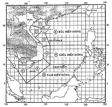
Note
|
Northern Gulf of Tonkin |
Southern Gulf of Tonkin |
|
Waters from Quang Tri to Quang Ngai |
Vùng biển từ Bình Định đến Ninh Thuận Waters from Binh Dinh to Ninh Thuan |
|
Waters from Binh Thuan to Ca Mau |
Waters from Ca Mau to Kien Giang |
|
Gulf of Thailand |
Northern East Sea |
|
Amid East Sea |
Southern East Sea |
ANNEX II
LIST OF RIVERS RELATED TO FLOOD ANNOUNCED BY
NATIONAL CENTRE FOR HYDROMETEOROLOGICAL FORECASTING
(Issued together with Decision No. 46/2014/QD-TTg dated 15 August 2014 of
the Prime Minister)
|
No. |
Name of rivers |
Hydrological Station |
Water level (or flow) corresponding to levels of alarm (m) |
||
|
I |
II |
III |
|||
|
1 |
Hong |
Hanoi |
9.50 |
10.50 |
11.50 |
|
2 |
Da |
Hoa Binh reservoir (flow to reservoir, m3/s) |
8,000 |
10,000 |
12,000 |
|
3 |
Thao |
Yen Bai |
30.00 |
31.00 |
32.00 |
|
4 |
Thao |
Phu Tho |
17.50 |
18.20 |
19.00 |
|
5 |
Lo |
Tuyen Quang |
22.00 |
24.00 |
26.00 |
|
6 |
Lo |
Vu Quang |
18.30 |
19.50 |
20.50 |
|
7 |
Thai Binh |
Phả Lai |
4.00 |
5.00 |
6.00 |
|
8 |
Cau |
Dap Cau |
4.30 |
5.30 |
6.30 |
|
9 |
Thuong |
Phu Lang Thuong |
4.30 |
5.30 |
6.30 |
|
10 |
Luc Nam |
Luc Nam |
4.30 |
5,30 |
6.30 |
|
11 |
Hoang Long |
Ben De |
3.00 |
3.50 |
4.00 |
|
12 |
Ma |
Giang |
4.00 |
5.50 |
6.50 |
|
13 |
Ca |
Nam Dan |
5.40 |
6.90 |
7.90 |
|
14 |
La |
Linh Cam |
4.50 |
5.50 |
6.50 |
|
15 |
Gianh |
Mai Hoa |
3.00 |
5.00 |
6.50 |
|
16 |
Huong |
Hue (Kim Long) |
1.00 |
2.00 |
3.50 |
|
17 |
Thu Bon |
Cau Lau |
2.00 |
3.00 |
4.00 |
|
18 |
Tra Khuc |
Tra Khuc |
3.50 |
5.00 |
6.50 |
|
19 |
Kon |
Tan An (Thanh Hoa) |
6.00 |
7.00 |
8.00 |
|
20 |
Da Rang |
Tuy Hoa (Phu Lam) |
1.70 |
2.70 |
3.70 |
|
21 |
Tien |
Tan Chau |
3.50 |
4.00 |
4.50 |
|
22 |
Hau |
Chau Doc |
3.00 |
3.50 |
4.00 |
ANNEX III
LIST OF RIVERS RELATED TO FLOOD ANNOUNCED BY REGIONAL AND PROVINCIAL HYDRO-METEOROLOGICAL STATIONS
(Issued together with Decision No. 46/2014/QD-TTg dated 15 August 2014 of
the Prime Minister)
|
No. |
Name of rivers |
Hydrological Station |
Water level (or flow) corresponding to levels of alarm (m) |
||
|
I |
II |
III |
|||
|
I |
Northwest hydro-meteorological stations |
|
|||
|
1 |
Da |
Muong Te |
285.00 |
287.50 |
290.00 |
|
2 |
Da |
Hoa Binh |
21.00 |
22.00 |
23.00 |
|
3 |
Nam Pan |
Hat Lot |
511.50 |
512.50 |
513.50 |
|
II |
Viet Bac hydro-meteorological stations |
||||
|
1 |
Thao |
Lao Cai |
80.00 |
82.00 |
83.50 |
|
2 |
Thao |
Yen Bai |
30.00 |
31.00 |
32.00 |
|
3 |
Thao |
Phu Tho |
17.50 |
18.20 |
19.00 |
|
4 |
Lo |
Ha Giang |
99.00 |
101.00 |
103.00 |
|
5 |
Lo |
Tuyen Quang |
22.00 |
24.00 |
26.00 |
|
6 |
Lo |
Vu Quang |
18.30 |
19.50 |
20.50 |
|
7 |
Lo |
Viet Tri |
13.70 |
14.90 |
15.90 |
|
8 |
Cau |
Bac Can |
132.00 |
133.00 |
134.00 |
|
9 |
Cau |
Gia Bay |
25.00 |
26.00 |
27.00 |
|
10 |
Chay |
Long Phuc (Bao Yen) |
71.00 |
73.00 |
75.00 |
|
III |
Northeast hydro-meteorological stations |
||||
|
1 |
Luoc |
Chanh Chu |
2.50 |
3.00 |
3.50 |
|
2 |
Van Úc |
Trung Trang |
2.00 |
2.30 |
2.60 |
|
3 |
Cau |
Dap Cau |
4,30 |
5,30 |
6,30 |
|
4 |
Thuong |
Phu Lang Thuong |
4,30 |
5,30 |
6,30 |
|
5 |
Luc Nam |
Luc Nam |
4,30 |
5,30 |
6,30 |
|
6 |
Duong |
Ben Ho |
6,80 |
7.50 |
8,40 |
|
7 |
Ky Cung |
Lang Son |
252.00 |
255.00 |
256.50 |
|
8 |
Giang |
Bang Giang |
180.50 |
181.50 |
182.50 |
|
IV |
North Delta hydro-meteorological stations |
||||
|
1 |
Hong |
Hanoi |
9.50 |
10.50 |
11.50 |
|
2 |
Hong |
Tien Duc |
4.80 |
5.60 |
6.30 |
|
3 |
Hong |
Hung Yen |
5.50 |
6.30 |
7.00 |
|
4 |
Hong |
Son Tay |
12.40 |
13.40 |
14.40 |
|
5 |
Thai Binh |
Pha Lai |
4.00 |
5.00 |
6.00 |
|
6 |
Luoc |
Trieu Duong |
4.90 |
5.40 |
6.10 |
|
7 |
Day |
Ninh Binh |
2.50 |
3.00 |
3.50 |
|
8 |
Day |
Ba Tha |
5.00 |
6.00 |
7.00 |
|
9 |
Day |
Phu Ly |
2.90 |
3.50 |
4.10 |
|
10 |
Dao |
Nam Dinh |
3.20 |
3.80 |
4.30 |
|
11 |
Hoang Long |
Ben De |
3.00 |
3.50 |
4.00 |
|
12 |
Gua |
Ba Nha |
2.00 |
2.40 |
2.70 |
|
13 |
Kinh Mon |
An Phu |
2.20 |
2.60 |
2.90 |
|
V |
North Central hydro-meteorological stations |
||||
|
1 |
Ma |
Ly Nhân |
9.50 |
11.00 |
12.00 |
|
2 |
Ma |
Giang |
4.00 |
5.50 |
6.50 |
|
3 |
Chu |
Bai Thuong |
15.00 |
16.50 |
18.00 |
|
4 |
Chu |
Xuan Khanh |
9.00 |
10.40 |
12.00 |
|
5 |
Buoi |
Kim Tan |
10.00 |
11.00 |
12.00 |
|
6 |
Yen |
Chuoi |
2.00 |
2.80 |
3.50 |
|
7 |
Ca |
Nam Dan |
5.40 |
6.90 |
7.90 |
|
8 |
Ca |
Do Luong |
14.50 |
16.50 |
18.00 |
|
9 |
Ca |
Dua |
20.50 |
22.50 |
24.50 |
|
10 |
La |
Linh Cam |
4.50 |
5.50 |
6.50 |
|
11 |
Ngan Pho |
Son Diem |
10.00 |
11.50 |
13.00 |
|
12 |
Ngan Sau |
Hoa Duyet |
7.50 |
9.00 |
10.50 |
|
VI |
Central central region hydro-meteorological stations |
||||
|
1 |
Gianh |
Mai Hoa |
3.00 |
5.00 |
6.50 |
|
2 |
Kien Giang |
Le Thuy |
1.20 |
2.20 |
2.70 |
|
3 |
Bo |
Phu Oc |
1.50 |
3.00 |
4.50 |
|
4 |
Hieu |
Dong Ha |
1.50 |
3.00 |
4.00 |
|
5 |
Thach Han |
Thach Han |
2.50 |
4.00 |
5.50 |
|
6 |
Huong |
Hue (Kim Long) |
1.00 |
2.00 |
3.50 |
|
7 |
Vu Gia |
Ai Nghia |
6.50 |
8.00 |
9.00 |
|
8 |
Han |
Cam Le |
1.00 |
1.80 |
2.50 |
|
9 |
Thu Bon |
Cau Lau |
2.00 |
3.00 |
4.00 |
|
10 |
Thu Bon |
Hoi An |
1.00 |
1.50 |
2.00 |
|
11 |
Tam Ky |
Tam Ky |
1.70 |
2.20 |
2.70 |
|
12 |
Tra Khuc |
Tra Khuc |
3.50 |
5.00 |
6.50 |
|
VII |
South Central hydro-meteorological stations |
||||
|
1 |
Lai Giang |
Bong Son |
6.00 |
7.00 |
8.00 |
|
2 |
Kon |
Tan An (Thanh Hoa) |
6.00 |
7.00 |
8.00 |
|
3 |
Ky Lo |
Ha Bang |
7.50 |
8.50 |
9.50 |
|
4 |
Ba |
Cung Son |
29.50 |
32.00 |
34.50 |
|
5 |
Da Rang |
Tuy Hoa (Phu Lam) |
1.70 |
2.70 |
3.70 |
|
6 |
Dinh Ninh Hoa |
Ninh Hoa |
4.00 |
4.80 |
5.50 |
|
7 |
Cai Nha Trang |
Dong Trang |
8.00 |
9.50 |
11.00 |
|
8 |
Cai Phan Rang |
Tan My |
36.00 |
37.00 |
38.00 |
|
9 |
Cai Phan Rang |
Phan Rang |
2.50 |
3.50 |
4.50 |
|
10 |
Luy |
Luy river |
26.00 |
27.00 |
28.00 |
|
11 |
Ca Ty |
Phan Thiet |
1.00 |
1.50 |
2.00 |
|
12 |
La Nga |
Ta Pao |
119.00 |
120.00 |
121.00 |
|
VIII |
Central Highlands hydro-meteorological stations |
||||
|
1 |
Po Ko |
Dak Mot |
584.50 |
585.50 |
586.50 |
|
2 |
Po Ko |
Dak To |
577.00 |
578.00 |
579.00 |
|
3 |
DakBla |
Kon Plong |
592.00 |
593.00 |
594.00 |
|
4 |
DakBla |
Kon Tum |
518.00 |
519.50 |
520.50 |
|
5 |
Ayun |
PoMoRe |
676.00 |
677.50 |
679.00 |
|
6 |
Ba |
An Khe |
404.50 |
405.50 |
406.50 |
|
7 |
Ba |
AyunPa |
153.00 |
154.50 |
56.00 |
|
8 |
KrongBuk |
Bridge 42 |
454.50 |
455.50 |
456.50 |
|
9 |
Krongno |
Duc Xuyen |
427.50 |
429.50 |
431.50 |
|
10 |
KrongAna |
Giang Sơn |
421.00 |
423.00 |
425.00 |
|
11 |
EakRong |
Bridge 14 |
300.50 |
301.50 |
302.50 |
|
12 |
Xrepoc |
Ban Don |
171.00 |
173.00 |
175.00 |
|
13 |
Dak Nong |
Dak Nong |
588.50 |
589.50 |
590.50 |
|
14 |
La Nga |
Dai Nga |
739.00 |
739.50 |
740.00 |
|
15 |
Cam Ly |
Thanh Binh |
831.00 |
832.00 |
833.00 |
|
IX |
Southern hydro-meteorological stations |
||||
|
1 |
Tien |
Tan Chau |
3.50 |
4.00 |
4.50 |
|
2 |
Tien |
My Thuan |
1.60 |
1.70 |
1.80 |
|
3 |
Tien |
My Tho |
1.40 |
1.50 |
1.60 |
|
4 |
Tien |
Cao Lanh |
1.90 |
2.10 |
2.30 |
|
5 |
Hau |
Chau Doc |
3.00 |
3.50 |
4.00 |
|
6 |
Hau |
Can Tho |
1.70 |
1.80 |
1.90 |
|
7 |
Hau |
Long Xuyen |
1.90 |
2.20 |
2.50 |
|
8 |
Sai Gon |
Phu An |
1.30 |
1.40 |
1.50 |
|
9 |
Sai Gon |
Dau Tieng |
2.60 |
3.60 |
4.60 |
|
10 |
Sai Gon |
Thu Dau Mot |
1.10 |
1.20 |
1.30 |
|
11 |
Dong Nai |
Ta Lai |
112.50 |
113.00 |
113.50 |
|
12 |
Dong Nai |
Bien Hoa |
1.60 |
1.80 |
2.00 |
|
13 |
Be |
Phuoc Hoa |
29.00 |
30.00 |
31.00 |
|
14 |
La Nga |
Phu Hiep |
104.50 |
105.50 |
106.50 |
|
15 |
Ben Da |
Can Dang |
10.00 |
11.00 |
12.00 |
|
16 |
Vam Co Dong |
Go Dau Ha |
1.30 |
1.50 |
1.70 |
|
17 |
Rach Tay Ninh |
Tay Ninh |
2.00 |
2.20 |
2.50 |
|
18 |
Vam Co Tay |
Moc Hoa |
1.20 |
1.80 |
2.40 |
|
19 |
Vam Co Tay |
Tan An |
1.20 |
1.40 |
1.60 |
|
20 |
Rach Ba Cang |
Ba Cang |
1.40 |
1.50 |
1.60 |
|
21 |
Rach Cai Coi |
Phu Duc |
1.40 |
1.50 |
1.60 |
|
22 |
Rach Nga Chanh |
Nha Dai |
1.50 |
1.60 |
1.70 |
|
23 |
Phuoc Xuyen canal |
Truong Xuan |
1.50 |
2.00 |
2.50 |
|
24 |
Rach ong Chuong |
Cho Moi |
2.00 |
2.50 |
3.00 |
|
25 |
Vinh Te canal |
Xuan To |
3.00 |
3.50 |
4.00 |
|
26 |
Canal13 |
Tri Ton |
2.00 |
2.40 |
2.80 |
|
27 |
Cai San canal |
Tan Hiep |
1.00 |
1.30 |
1.60 |
|
28 |
Cai Con |
Phung Hiep |
1.10 |
1.20 |
1.30 |
|
29 |
Ganh Hao |
Ca Mau |
1.00 |
1.10 |
1.20 |
|
30 |
Ganh Hao |
Ganh Hao |
1.60 |
1.80 |
2.00 |
ANNEX IV
TABLE OF WIND AND WAVE LEVEL
(Issued together with Decision No. 46/2014/QD-TTg dated 15 August 2014 of
the Prime Minister)
|
Wind level |
Wind speed |
Average wave height |
Harmful level |
|
|
Beaufort |
m/s |
km/h |
M |
|
|
0 |
0 - 0.2 |
<> |
- |
Mild wind No harm |
|
1 |
0.3 - 1.5 |
1 - 5 |
0.1 |
|
|
2 |
1.6 - 3,3 |
6 - 11 |
0.2 |
|
|
3 |
3.4 – 5.4 |
12 - 19 |
0.6 |
|
|
4 |
5.5 – 7.9 |
20 - 28 |
1.0 |
- Small trees with leaves shaking, affecting rice - Somewhat rough sea, fishing boat swinging |
|
5 |
8.0 - 10.7 |
29 - 38 |
2.0 |
|
|
6 |
10.8 – 13.8 |
39 - 49 |
3.0 |
- Trees shaking. Hard to go against the wind - Rough sea. Dangerous for boats |
|
7 |
13.9 – 17.1 |
50 - 61 |
4.0 |
|
|
8 |
17.2 - 20.7 |
62 - 74 |
5.5 |
- Wind break tree branches, damaging the roofs of houses. Impossibly go against the wind - Very rough sea. So dangerous for boats |
|
9 |
20.8 – 24.4 |
75 - 88 |
7.0 |
|
|
10 |
24.5 – 28.4 |
89 - 102 |
9.0 |
- Breaking down trees, buildings, electric poles. Causing severe damages - Extremely rough sea. Sinking boats |
|
11 |
28.5 - 32.6 |
103 - 117 |
11.5 |
|
|
12 |
32.7 – 36.9 |
118 - 133 |
14.0 |
- Extremely destructive - Extremely strong waves. Sinking large boats
|
|
13 |
37.0 - 41.4 |
134 -149 |
|
|
|
14 15 16 17 |
41.5 – 46.1 46.2 - 50.9 51.0 – 56.0 56.1 - 61.2 |
150 - 166 167 - 183 184 - 201 202 - 220 |
|
|
ANNEX V
LIST OF AGENCIES PROVIDING AND PROVIDED WITH
NEWSCASTS OF FORECASTING AND WARNING OF NATURAL DISASTERS
(Issued together with Decision No. 46/2014/QD-TTg dated 15 August 2014 of
the Prime Minister)
|
No. |
Agencies provided with newscasts of forecasting and warning of natural disasters |
Agencies providing newscasts of forecasting and warning of meteorological, hydrological, oceanographic natural disasters |
Agencies providing newscasts of earthquake and tsunami warning |
|
1 |
Office of the Party Central Committee |
National Centre for Hydrometeorological Forecasting |
Institute of Geophysics |
|
2 |
Government Office |
National Centre for Hydrometeorological Forecasting |
Institute of Geophysics |
|
3 |
Central Steering Committee for Natural Disaster Prevention and Control |
National Centre for Hydrometeorological Forecasting |
Institute of Geophysics |
|
4 |
National Committee for Search and Rescue |
National Centre for Hydrometeorological Forecasting |
Institute of Geophysics |
|
5 |
Ministry of Defense |
National Centre for Hydrometeorological Forecasting |
Institute of Geophysics |
|
6 |
Ministry of Agriculture and Rural Development |
National Centre for Hydrometeorological Forecasting |
Institute of Geophysics |
|
7 |
Ministry of Industry and Trade |
National Centre for Hydrometeorological Forecasting |
Institute of Geophysics |
|
8 |
Ministry of Transportation |
National Centre for Hydrometeorological Forecasting |
Institute of Geophysics |
|
9 |
Ministry of Information and Communications |
National Centre for Hydrometeorological Forecasting |
Institute of Geophysics |
|
10 |
Ministry of Natural Resources and Environment |
National Centre for Hydrometeorological Forecasting |
Institute of Geophysics |
|
11 |
Ministry of Science and Technology |
National Centre for Hydrometeorological Forecasting |
Institute of Geophysics |
|
12 |
Voice of Vietnam |
National Centre for Hydrometeorological Forecasting |
Institute of Geophysics |
|
13 |
Vietnam Television |
National Centre for Hydrometeorological Forecasting |
Institute of Geophysics |
|
14 |
Vietnam News Agency |
National Centre for Hydrometeorological Forecasting |
Institute of Geophysics |
|
15 |
People Newspaper |
National Centre for Hydrometeorological Forecasting |
Institute of Geophysics |
|
16 |
Government E-portal |
National Centre for Hydrometeorological Forecasting |
Institute of Geophysics |
|
17 |
Vietnam Maritime Communication and Electronics LLC |
National Centre for Hydrometeorological Forecasting |
Institute of Geophysics |
|
18 |
Office of the Provincial Party Committee |
Regional and provincial hydro-meteorological stations |
|
|
19 |
Office of provincial People’s Committee |
Regional and provincial hydro-meteorological stations |
|
|
20 |
Provincial Committees for Flood and Storm Control and Search and Rescue |
Regional and provincial hydro-meteorological stations |
|
|
21 |
Provincial radiobroadcasting and television stations |
Regional and provincial hydro-meteorological stations |
|
|
22 |
Provincial Departments of Natural Resources and Environment |
Regional and provincial hydro-meteorological stations |
|
|
23 |
Provincial daily newspapers |
Regional and provincial hydro-meteorological stations |
|
|
24 |
Other agencies |
As agreed with the agencies under the National Centre for Hydrometeorological Forecasting and the Ministry of Natural Resources and Environment |
As agreed with the Institute of Geophysics and Vietnam Academy of Science and Technology |
ANNEX VI
TROPICAL DEPRESSION AND STORM WARNING SIGNALS
(Issued together with Decision No. 46/2014/QD-TTg dated 15 August 2014 of
the Prime Minister)
|
Signal form |
Meaning of signal |
|
One flashing red light
|
Tropical depression or storm appearing in the East Sea |
In daytime, boats at sea uses pennant in lieu of light signal.
Red pennant (right triangle), with length from 1-1.5 m, the width is ½ of length.
ANNEX VII
FLOOD WARNING SIGNALS
(Issued together with Decision No. 46/2014/QD-TTg dated 15 August 2014 of
the Prime Minister)
|
Signal |
Signal form |
Meaning of each signal |
|
Alarm No. 1 |
One flashing blue light
|
The water level in the control area reaches the alarm No. 1 |
|
Alarm No. 2 |
Two flashing blue lights
|
The water level in the control area reaches the alarm No. 2 |
|
Alarm No. 3 |
Three flashing blue lights
|
The water level in the control area reaches the alarm No.3 |


ANNEX VIII
REGULATION AND LOCATION OF SIGNAL FLARING
(Issued together with Decision No. 46/2014/QD-TTg dated 15 August 2014 of the
Prime Minister)
I. REGULATION ON SIGNAL FLARING UPON TROPICAL DEPRESSION AND STORMS
1. When there is a “ Newscast of storm in the East Sea”, “Newscast of nearshore tropical depression”, “Newscast of nearshore storm”, “Newscast of emergency storm”, flare signal 2 times/night with 06 red shots/01 time divided by 02 salvos with 03 consecutive shots, the first salvo is 03 minutes apart from the second one.
2. Time of 1st signal flaring is from 19:30 to 20:00 pm. The time of 2nd signal flaring is from 4:30 to 5:00 am
In special case or emergency, the units may increase the number of time to flare the signals, including daytime.
II. LOCATION TO FLARE SIGNALS FOR WARNING OF TROPICAL DEPRESSION AND STORMS
1. Military Zone 3 flares signals at 10 points:
- Quang Ninh province on Co To island (Border Post 16) and Ngoc Vung island (Border Post 24).
- Hai Phong city on Cat Ba island (Border Post 54), Hon Dau island, Do Son town (Border Post 38), Long Chau control station in Cat Hai district (Border Post 54).
- Thai Binh province at Diem Dien estuary, Thai Thuy (Border Post 64).
- Nam Dinh province at Ngoc Lam, Nghia Hung (Border Post 100), Ba Lat estuary (Con Lu), Xuan Thuy (Border Post 84), Doanh Chau, Hai Hau (Border Post 92).
- Ninh Binh province at Day estuary, Kim Son (Border Post 104).
2. Military Zone 4 flares signals at 17 points:
- Thanh Hoa province at Dau Bo mount, Hoang Truong (Border Post 118), Hon Me island (signal flared by soldiers on island), Ne island (signal flared by soldiers on island), Truong Le, Sam Son (Border Post 112), Du Xuyen mount, Tinh Gia (Border Post 126) and Southeast of Nghi Son (Border Post 130).
- Nghe An province at Hon Mat (signal flared by soldiers on island).
- Ha Tinh province at Cua Sot, Thach Ha (Border Post 164).
- Quang Binh province at Gianh estuary (Border Post at border gate of Gianh estuary port), Ron estuary, Quang Trach (Border Post 184), Border control station at Nhat Le estuary, Dong Hoi (Border Post 196).
- Quang Tri province on Con Co island (signal flared by soldiers on island), Cua Viet, Gio Linh (Border Post at border gate of Cua Viet port), Cua Tung area (Border Post 204).
- Thua Thien Hue province at Thuan An estuary, Thuan An town (Border post at Thuan An port), sea light area at Chan May port, Phu Loc district (Border post at Chan May port), Phong Hai commune, Phong Dien district (Border Post 216), Tu Hien estuary, Phu Loc district (Border Post 228).
3. Military Zone 5 flares signals at 16 points:
- Da Nang city on Son Tra peninsula (Border Post 228), Hai Van pass,Lien Chieu (Border staff division of Da Nang).
- Quang Nam province at Cu Lao Cham, Hoi An (Border Post 276), Ban Than cape, Nui Thanh (Border Post at border gate of Ky Ha port), Cua Dai, Hoi An town (Border Post 260).
- Quang Ngai province on Ly Son island (Border Post 328), Sa Huynh, Duc Pho (Border Post 304), Son Tra, Binh Son (Border Post at border gate of Dung Quat port),
- Binh Dinh province on Cu Lao Xanh, Quy Nhon city (Border Post 332),
- Phu Yen province at Cau river estuary, Cau river (Border Post 348).
- Khanh Hoa province at Binh Ba, Cam Ranh (Border Post 392), Hon Mun, Nha Trang city (Border Post 388), Dam Mon, Van Ninh (Border Post 358).
- Ninh Thuan province at Son Hai, Ninh Phuoc (Border Post 416), Nhon Hai, Ninh Hai (Border Post 408), Vinh Hy, Ninh Hai (Border Post 404).
4. Military Zone 7 flares signals at 7 points:
- Binh Thuan province at Cao Cat mount, Phu Quy (Border Post 464), Thanh Hai, Phan Thiet (Border Post 444).
- Ba Ria – Vung Tau province at Con Dao (Border Post 540), Ben Da, Vung Tau city (Border Post 522).
- HCM City at Thach An commune, Can Gio (Border Post 554), Ly Nhon, Can Gio (Border Post 554), Dong Hoa, Can Gio (Border Post 562).
5. Military Zone 9 flares signals at 19 points:
- Tien Giang province at Vam Lang, Go Cong Dong (Border Post 578), Cua Tieu, Go Cong Dong (Border Post 582).
- Ben Tre province at Ham Luong estuary, An Thuy (Border Post 598).
- Tra Vinh province at My Long town, Cau Ngang (Border Post 618).
- Soc Trang province at Tran De estuary, Long Phu (Border Post 638), Vinh Chau, Vinh Chau town (Border Post 646).
- Bac Lieu province at Ganh Hao estuary, Ganh Hao town (Border Post 668).
- Ca Mau province at Hon Khoai, Ngoc Hien (Border Post 700), Ong Doc estuary, Ong Doc town (Border Post 692), Hon Chuoi, Tran Van Thoi (Border Post 704), Kinh Hoi, U Minh (Border Post 696).
- Kien Giang province at An Thoi, Phu Quoc (Border Post 750), Tho Chu island, Phu Quoc (Border Post 770), Nam Du, Kien Hai (Border Post 742), Vinh Lac ward, Rach Gia (Border Command of Kien Giang province).
- An Giang province at Vinh Xuong, Tan Chau (Border Post 905), Vinh Nguon, Chau Doc (Border Post 945).
- Dong Thap province at Thong Binh, Tan Hong (Border Post 905), Cau Van, Hong Ngu (Border Post 917).
6. People’s Navy flares signals at 13 points:
- Bach Long Vi island
- Southern Long Chau 10-15 knots.
- Southern Ha Mai 10-15 knots.
- Eastern Son Tra Cape 15-20 knots.
- Southeastern Hon Tre 15-20 knots.
- Southeastern Da Vach cape 15-20 knots.
- Southeastern Tho Chu 30 knots
- Da Tay island: 1 point
- Lot 3, Phuc Tan: 1 point
- Lot 1, Tu Chinh: 1 point
- Toc Tan island: 1 point
- Ba Ke area (DK1/9).
- Ca Mau shoal (DK1/10).
- Da Lon island
- Nam Yet island
- Song Tu Tay island
7. Air Defense - Air Force.
Location of airplane on duty to be ready for support upon occurrence of natural disasters :
- Hoa Lac Airport.
- Gia Lam Airport.
- Da Nang Airport.
- Tan Son Nhat Airport.
8. Command of Border Guard
In addition to signal flaring under assignment of military zone and Committees for Flood and Storm Control and Search and Rescue of provinces and centrally-run cities, the Command of Border Guard shall flare signals at 04 points: Squadron 38 in the city of Hai Phong, Hai Group 48 in Binh Dinh province, Squadron 28 in Kien Giang province, Squadron 18 in the city of Vung Tau and 27 Flotillas of 27 coastal provinces.
ANNEX IX
SEISMIC INTENSITY ON THE GROUND
(Issued together with Decision No. 46/2014/QD-TTg dated 15 August 2014 of
the Prime Minister)
A. CLASSIFICATION OF WORKS DAMAGES
I. TYPE OF WORKS (Houses built without seismic resistance measures)
Type A: Houses built of stone with poor hardness, rural architecture, houses built of clunch or clay.
Type B: Houses built of ordinary bricks, houses with large blocks and prefabricated materials, half-timbered houses or house built of hard hewn stones.
Type C: Houses built of reinforced concrete or houses built of fine wood.
II. CHARACTERISTICS OF NUMBERS
Few: nearly 5%, a few: nearly 50%, majority: nearly 75%
III. CLASSIFICATION OF DAMAGE
Level 1 – Mild damage: Cracking of mortar and drop of small pieces of mortar
Level 2 – Moderate damage: Small cracks on the wall, drop of rather large pieces of mortar, drop of tiles, cracks in the chimney, drop of chimney parts.
Level 3- Heavy damage: large and deep cracks on the wall, drop of chimney.
Level 4: Destruction: cracks through walls, collapsed parts of houses, damage of linking places between separate parts of houses, collapsed interior wall and skeleton wall
Level 5 – Collapse: Houses completely destroyed.
B. CLASSIFICATION OF IMPACT OF EARTHQUAKE ON MSK – 64 SCALE
|
Seismic
intensity |
Peak Ground acceleration g* |
Description of signs |
|
I |
|
Earthquake not felt The strength of vibration below the limit of feeling, only meter can detect and record it. |
|
II |
|
Earthquake felt little (very slight) Earthquake is felt only by those in a state of quiet in their house |
|
III |
|
Weak earthquake Earthquake is felt by few people in the open air in favorable conditions. Vibration seems to be created by a light truck passing. Objects hung in houses sways lightly and stronger if on higher floors. |
|
IV |
|
Earthquake clearly felt Earthquake is felt by many people in their houses and few in the open air. There are people awake but nobody scares at all. Glass windows, doors and dishes rattle. Wooden floors and walls creak. Tables, chairs and furniture start shaking. Hung objects sway lightly. Water in open container somewhat shake. People sitting in their cars can feel the earthquake. |
|
V |
0.012 - 0.030 |
Awakening Earthquake is felt by everyone inside their houses and many people in the open air. A lot of people are awake. Some afraid run out of their houses. Animals are panicked. Houses shake completely. Hung objects sway sharply. Hung frames move from their places, In rare case, pendulum clock stops. Some things unsteady collapse or move. Window and doors unfastened are opened and then slammed. Water in open container spill out a little. Vibration is created by heavy things dropping in houses. |
|
VI |
0.03 - 0.06 |
Fear Inside houses as well as in the open air, most people feel the earthquake. Many people in their houses run out. Some people lose their balance. Animals run out of their barns. In some cases, dishes and glass objects can be broken, books fall off the shelf, table and chair and heavy objects can move. Noise of small bell on belfry can be heard Few houses of type B and a lot of houses of type A are damaged at level 1; a lot of houses are damaged at level 2. In a few cases, there may be cracks as large as 01 cm on the damp ground and landslides occur in the mountainous areas. The flow of water source and water level in the wells can be changed. |
|
VII |
0.06 - 0.12 |
House damage Most people were scared and ran out of their houses. Many people hardly stood. The drivers are also aware of the earthquake. Large church bells chimed. A lot of houses of type C are damaged at level 1 and houses of type B are damaged at level 2 and houses of type C are damages at level 3 and some at level 4. In separate cases, there are landslides on the section of road located on the slopes and cracks in the pavement. There are damaged joints in pipes and cracks in the stone fence. Waves appear in lake, the water becomes cloudy due to mud stirred up. Water level in wells and flow of water sources. In some cases, there appear new water sources or old water sources disappear. In separate cases, there are landslides in riverside composed of sand or small grits. |
|
VIII |
0.12 - 0.24 |
House destruction Terrible fear, even drivers are afraid. Tree branches are broken here and there. Tables, chairs and heavy objects are moved or collapsed. Some hung lights are damaged. A lot of houses of type C are damaged at level 2, some at level 3. A lot of houses of type B are damaged at level 3, some at level 4. A lot of houses of type A are damaged at level 4, some at level 5. There are cases of break in pipe joints. Commemorative statue are moved. Stone steles are fallen. Stone fence is damaged. Small landslides in steep slopes, in deep indentations and bump on roads, ground is cracked up to several centimeters wide. There appear new ponds. Sometimes dry wells are filled with water or full ones become dry. In many cases, there is change of flow of water sources and water level in wells. |
|
IX |
0.24 - 0.48 |
Houses completely destroyed Absolutely horrible. Tables, chairs, furniture are damaged heavily. Agitated animals run roaring. A lot of houses of type C are damaged at level 3, some at level 4. A lot of houses of type B are damaged at level 4, some at level 5. A lot of houses of type A are damaged at level 5. Commemorative statue are collapsed, heavy damage of artificial water tank, underground pipe partially breaks. In some cases, the rail is bent and road is damaged. In floodplains, the accretion of sand and mud can be seen. Ground is cracked up to 10 cm wide and over 10 cm on slope and along riverbank and many cracks found on the ground. Rocks fall down, landslides occur and there appear high waves. |
|
X |
0.48 - 0.80 |
Houses completely damaged A lot of houses of type C are damaged at level 4, some at level 5, houses of typee B are damaged at level 5, most of houses of type A are damaged at level 5. Harmful damage to dykes and dams, heavy damage to bridges. Rail somewhat bent, underground pipe bent or broken. Layer of stones and asphalt become a wavy surface. Ground cracked a few dm and up to 1 m in some cases. Parallel with the bed of water flow, there appear large faults. Friable rocks slide from steep slopes. There may be major landslide along riverbank and steep seashore. Water spilled out of canal, lake, river,…there appear new lakes. |
|
XI |
>0.8 |
Disaster Heavy damage to even better house, bridges, dam and railway, macadamized road ruined, underground pipe damaged. Ground distorted with large cracks and faults which move vertically and horizontally; mountains fall at many places. To determine the strength level, there must be special survey. |
|
XII |
|
Topographical change Heavy damage or actual destruction of all works on and under the ground. The ground surface is changed completely. There are large cracks which move vertically and horizontally. Mountain and riverbank collapse in large areas. Lakes appear and waterfall formed, river flow changed. To determine the strength level, there must be special survey. |
ANNEX X
RELATION BETWEEN EATHQUAKE MAGNITUDE (M),
CLASSIFICATION OF EARTHQUAKE, SEISMIC INTENSITY ON THE GROUND (I), IMPACT AND
FREQUENCY OF EARTHQUAKE
(Issued together with Decision No. 46/2014/QD-TTg dated 15 August 2014 of
the Prime Minister)
|
Magnitude (M) |
Classification |
Seismic
intensity on the ground |
Impact of earthquake |
Annual
average frequency in the workd |
|
<> |
Micro earthquake |
I |
Not felt or felt by very sensitive people. Recoded by seismic recorder. |
Continuously, several million earthquakes per year |
|
2.0 - 2.9 |
Small |
I - II |
A number of people can feel very light vibration. No damage to constructional works. |
Over 1 million earthquakes per year |
|
3.0 – 3.9 |
II - IV |
Felt by a number of people, but caused rare damage. Objects in houses are seen vibrating |
Over 100,000 earthquakes per year |
|
|
4.0 – 4.9 |
Minor |
IV-VI |
Objects in houses vibrate and emit noise. A lot of people can feel the earthquake. People outside their house can feel light vibration. Generally, no damage or minor damage. Moderate or significant damage is seldom. |
10,000- 15,000 earthquakes per year |
|
5.0 – 5.9 |
Moderate |
VI -VIII |
Can cause moderate and heavy damages to constructional works with poor architecture and no damage to the ones with good architecture. Everyone can feel the earthquake. Can cause death depending on its impact. |
1,000 – 1,500 earthquakes per year |
|
6.0 – 6.9 |
Major |
VII - X |
Can cause damages or destruction in crowded residential areas. Cause damage to most constructional works. The works with good architecture remain but can have minor to moderate damages. The works with bad architecture have moderate to heavt damages. Area with earthquake felt is larger, up to hundreds of kilometers from the earthquake hypocenter. Areas far away from the hypocenter also have damages at any level. Strong to intense vibration in areas near the hypocenter. The damage threshold between 0 and about 25,000 people. |
100 -150 earthquakes per year |
|
7.0 – 7.9 |
Great |
VIII - XII |
Can cause damages to many or all of constructional works in many areas. A number of works collapse partially or completely or are severely damaged. The works with good architecture are definitely damaged. Earthquake can be felt in very large areas. The damage threshold between 0 and about 250,000 people. |
10 – 20 earthquakes per year |
|
8.0 – 8.9 |
Macro |
Can cause damages to constructional works with bad architecture are damaged severely. Cause moderate to heavy damages to ordinary works and works designed to resist earthquakes. Damages caused in large areas. Can cause complete destruction in unusually large areas. The damage threshold between 100 and about 1000,000 people. However, a number of earthquakes with such magnitude cause no damage to people. |
1 earthquake each year (rarely none, 2 or more than 2 earthquakes |
|
|
9.0 – 9.9 |
Can cause severe damages to all most of constructional works with great destructive level. Cause damage and vibration to quite far locations. Change the ground topography. The damage threshold between 1,000 and several million people. |
1 earthquake in 5-50 years |
||
|
10.0 or higher |
Huge |
X - XII |
Cause damages and destruction in large areas. Destroy almost works completely and rapidly. Earthquake can be felt a very far distance from the hypocenter (thousand miles). The damage threshold can exceed 25,000 people…major change of ground topography. Impact of earthquake shall last for an extremely long period of time. No record of such earthquake so far. |
No earthquake like such per year (still unknown, extremely rare or impossible/possible occurrence). |
ANNEX XI
MAP OF EARTHQUAKE ZONING IN THE TERRITORY OF
VIETNAM AND SURROUNDING AREAS
(Issued together with Decision No. 46/2014/QD-TTg dated 15 August 2014 of
the Prime Minister)
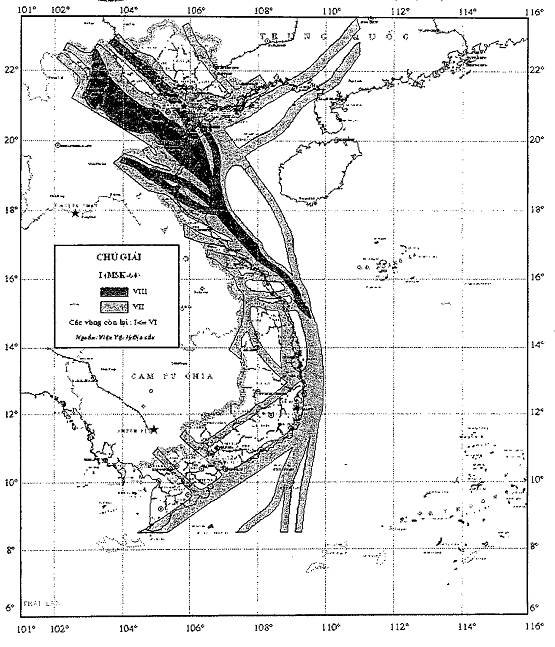
ANNEX XII
MAP OF REGIONS AS EARTHQUAKE GENERATION SOURCES
POSSIBLY CAUSING TSUNAMI IN VIETNAM
(Issued together with Decision No. 46/2014/QD-TTg dated 15 August 2014 of
the Prime Minister)
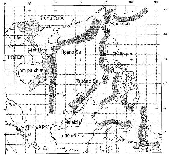
Name of source areas numbered on the map: 1- Taiwan sea source area, 2 – Manila deep gutter source area, 3- Sulu sea source area, 4 – Celebes sea source area, 5- Southern Banda sea source area, 6- Northern Banda sea source area, 7-Southern East Sea source area, 8 – Palawan source area, 9 – Western East Sea source area (Meridian 109 °).