Nội dung toàn văn Decision No. 1401/QD-BGTVT 2010 approval of the detailed planning of Nghi Son Thanh Hoa seaport
|
MINISTRY OF TRANSPORT |
SOCIALIST
REPUBLIC OF VIETNAM |
|
No.: 1401/QD-BGTVT |
Ha Noi, 26 May 2010 |
DECISION
APPROVAL OF THE DETAILED PLANNING OF NGHI SON – THANH HOA SEAPORT TILL 2020, ORIENTATING TILL 2030
THE MINISTER OF TRANSPORT
Pursuant to Construction Law dated 26 November 2003;
Pursuant to Maritime Code of Vietnam dated 14 June 2005;
Pursuant to governmental Decree No. 51/2008/ND-CP dated 22 April 2008 stipulating the functions, duties, empowerment and organizational structure of the Ministry of Transport;
Pursuant to governmental Decree No. 92/2006/ND-CP dated 7 September 2006 regarding the preparation, appraisal, approval and management of the master socio-economic development planning and Decree No. 04/2008/ ND-CP dated 11 January 2008 amending and supplementing a number of articles defined in Decree 92/2006/ ND-CP;
Pursuant to Decision No. 2190/QD-TTg dated 24 December 2009 approving the Planning on Vietnam’s seaport system development till 2020, orientating till 2030;
Pursuant to Decision No. 16/2008/QD-TTg dated 28 January 2008 issued by the Prime Minister proclaiming the list of Vietnam seaport categories;
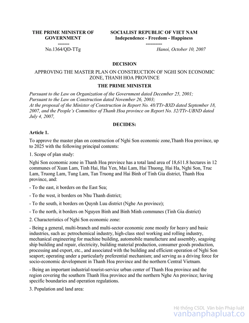
Pursuant to Decision No. 1364/QD-TTg dated 10 October 2007 issued by the Prime Minister approving the General Planning of Nghi Son Economic Zone construction, Thanh Hoa Province;
Pursuant to Decision No. 2619/QD-BGTVT dated 8 September 2002 issued by the Minister of Transport approving the detailed planning of North Central seaports (group 2) till 2010;
Pursuant to Decision No. 2249/QD-BGTVT dated 31 July 2008 issued by the Minister of Transport approving the detailed planning of Nghi Son Seaport, Southern Bay area, Bien Son – Thanh Hoa island, till 2015, orientating till 2025;
Based on official document No. 106/TTr-UBND dated 15 December 2009 issued by the People’s Committee of Thanh Hoa Province approving the detailed planning of Nghi Son – Thanh Hoa Seaport in attachment with the planning document; report from the consulting agency who inspects and appraises the planning, opinions from the related agencies; official document No. 2196/UBND-CN dated 10 May 2010 of Thanh Hoa People’s Committee attached with document 491/BQLKTNS-QLXD dated 5 May 2010 from the Management Unit of Nghi Son Economic Zone regarding the explanation and clarification of the planning appraisal opinions and opinions from the related agencies;
In consideration of the requests from the Director General of the Planning and Investment Department;
HEREBY DECIDES:
Article 1. The approved detailed planning of Nghi Son Seaport till 2020, orientating till 2030, covers the following key issues:
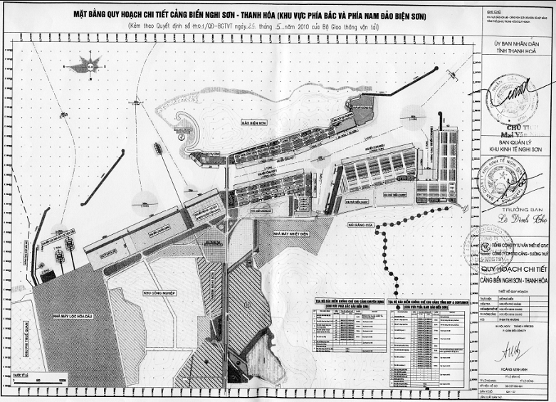
(Attached with the site planning drawing and detailed appendix.)
1. Borderlines of the approved planning
The Northern and Southern Bay areas of Bien Son Island and the development area in Hon Me Island. Total area of the seaport is 2,020 ha (including land and water area).
- The North: from the breakwater of the export port of Nghi Son Oil Refinery (to be constructed);
- The South: bordering Quynh Luu coastal area, Nghe An Province;
- The East: bordering the East Sea;
- The West: bordering Road 513 of Nghi Son Economic Zone
2. Functions and duties
Nghi Son – Thanh Hoa Seaport is the national multipurpose port, the hub of the area (Type 1), meeting the demands for goods import and export for Nghi Son Economic zone, Thanh Hoa Province and the neighboring areas. It houses the following specialized terminals:
To the North of Bien Son Island located the specialized terminals for receiving 30,000 ÷ 50,000 DWT vessels carrying petrochemical, cement, bulk, liquid commodities.
To the South of Bien Son Island located the multipurpose terminals and container terminals for 30,000 ÷ 50,000 DWT vessels, and specialized terminals.
At Hon Me Island located the terminals serving transshipment, shelter from storms, tourism, and national defense purposes.
3. Planning indicators
3.1. Goods quantity indicators
Unit: 1,000 T
|
No. |
Commodity |
2015 |
2020 |
2030 |
|
1 |
General goods + container |
6,900 |
9,840 |
18,000 |
|
2 |
Goods from cement factory(ies) |
7,600 |
10,310 |
10,310 |
|
3 |
Clinkers |
1,500 |
3,000 |
3,000 |
|
4 |
Petroleum |
19,000 |
19,000 |
38,000 |
|
5 |
Coal of thermal power plant(s) |
1,000 |
2,500 |
5,500 |
|
|
Total: |
36,000 |
44,650 |
74,810 |
3.2. Fleet-related indicators
- The period till 2020: receiving the vessels of 30,000 – 50,000 DWT.
- The period till 2030: receiving the vessels of over 50,000 DWT.
- Hon Me Island transshipment area will receive crude tankers and the plan for receiving imported coal vessels of over 100,000 DWT will be studied.
3.3. Land use demand:
Total planning area is 2,020 ha, of which the land area is 916.8 ha and the water area is 1,103.2 ha (including the area for Nghi Son Oil Refinery terminal).
4. Port site planning
4.1. Functional zoning
The port includes: multipurpose terminal, container terminal, specialized terminals for Nghi Son Economic Zone (export terminals of the Plants on oil refinery, thermal coal, cement, ship building, petroleum import and export…). Based on the specialized functions, the port will zoned as follows:
4.1.1. The area to the North of Bien Son Island will include:
- Terminal for the exports from the oil refinery plant: 8 specialized terminals for 10,000 – 50,000 DWT vessels, 210 ha in area;
- Specialized terminal for gas and/or LNG vessels, 45 ha in area, 1,000m in length;
- Specialized terminal for industrial parks to receive 50,000 DWT vessels, 51.8 ha in area, 1,150m in length;
- The terminal for inbound tourism and logistic services: 33.5 ha
4.1.2. The area to the South of Bien son Island will include:
- Multipurpose terminal: with 19 piers for 30,000 DWT vessels, 136.1 ha in area, 4,605m in length. By 2020, 11 terminals will be constructed.
- Container terminal: with 10 piers for 50,000 DWT vessels, 180.1 ha in area, 2,500m in length; by 2020, 6 terminals will be constructed.
- Terminal for the thermal power Plant: with 5 piers, of which one for 30,000 DWT vessels; it is likely to consider the visit of 50,000 DWT vessels; remaining piers are for smaller vessels of 5,000 – 7,000 T, 16 ha in area, 560m in length.
4.1.3. Hon Me Island area includes: Terminal for transshipment for crude tankers (the plan for imported coal vessels will be studied) of over 100,000 DWT; storm shelter area for vessels and/or boat.
4.1.4. Other functional areas include:
- Areas for water, navigation channel and protection structures: 1,103.2 ha (500.8 ha to the South of Bien Son Island, 602.4 ha to the North of Bien Son Island);
- Roads: 50.3 ha (34.7 ha to the South of Bien Son Island and 15.6 ha to the North of Bien Son Island);
- Area for railway development: 33.8 ha;
- Area for the port authority: 5.1 ha;
- Port servicing area: 11.5 ha;
- Parking area: 3.4 ha;
- Logistic service area: 57.9 ha;
- Green area: 50.5 ha (13.7 ha to the South of Bien Son Island and 36.8 ha to the North of Bien Son Island).
4.2. Pier planning
- The area of each pier must be sufficient to facilitate operation, port and general safety for the terminal.
- The port planning area includes the piers completed constructed, under construction and not yet constructed but selected site, therefore, the planning of the piers in the terminals will base on the remaining available area located within the planning area, in line with the master planning and completed projects. Locations of the piers will be specified by specialized authorities during the planning development.
5. Technical infrastructure system
The technical infrastructure connecting the seaport to the outer transportation infrastructure will be in line with the master planning of the Economic Zone.
5.1. Planning of the road leading to the seaport and internal roads inside the port area
- The road leading to the port:
+ Arterial road to the East – West direction: connecting the seaport and the central road of the economic zone to Highway 1A and North – South Highway, with 8 lanes, starting from the feeder road at Dong Chua Lake (in the direction of Nghi Son – Bai Tranh route).
+ Road 513 (along the shore): City road Grade II, with 4 lanes, North – South direction, connecting the port’s functional areas from the Northern to the Southern areas and to Nghi Son oil refinery Industrial Park. The alignment and dimension of the cross section will be in line with the master planning of Nghi Son Economic Zone and the approved planning of Road 513.
- Inland roads of the seaport: adjacent to the logistic area of the port, in parallel with the key roads connected to the port, with 2 lanes at least, 20 km/h speed, H30 load.
- Internal roads in the seaport area: in line with the planning for the loading and unloading technology, ensured to facilitate transportation.
- Railway: an area of the planning land will be developed into railway; investment location and scale will be in line with the master planning and development demand of Nghi Son Economic Zone.
5.2. Planning of the navigation channel and turn-around area
5.2.1. The Southern area of Bien Son Island:
- Navigation channel: till 2020, one-lane channel, two-way, 7km in length, 150m wide, capable for 30,000 DWT fully loaded vessels, 50,000 DWT underloaded vessels.
- Vessel turn-around area will include 2 sub-areas, capable for 30,000 – 50,000 DWT vessels. The turn-around area for 50,000 DWT vessels will be constructed once the breakwater is completed to serve the demand of the vessels.
5.2.2. The Northern area of Bien Son Island: Specialized navigation channel and turn-around area for industrial parks will be developed based on the demand and investment capacity of the industrial parks.
5.3. Leveling-related planning
- Elevation of the road and yard system inside the seaport area will be planned based on the highest elevation of the terminals + 5.0 of the Nautical Chart and master planning of the economic zone.
- Filled sand will be exploited from the mines in Nghi Son Economic Zone and some of the dredged sand from the port water area may also be used.
5.4. Power supply planning
- Power supply target applicable to the industrial areas inside the seaport is 150 kW/ha. Total electricity consumption for the period of 2020 is estimated to be 99,716 KW; and up to 207,184 KW by the completion time.
- The power source to be supplied to the seaport will be taken from the 22KV line of 110/35/22KV-25MVQ stations nearby in the area.
5.5. Planning for water supply and drainage
- Clean water will be conducted from the Water Plant in Dong Rua Lake and Con Cat Lake area and alongside the road connected to the seaport areas. Diameter of the water pipelines ranges from D150 to D400.
- Total water consumption demand of the entire seaport area is estimated to be:
+ 2020 period: 6,146 m3/day.night
+ Completion stage: 14,790 m3/day.night
- Water drainage system will ensure to meet the drainage demand; wastewater will be treated in accordance with environmental protection regulations.
6. Estimated investment capital based on the planning
|
No. |
Functional area |
Estimated investment cost |
|
|
Till 2020 |
Till 2030 |
||
|
Southern area of Bien Son Island |
6,276.65 |
12,647.12 |
|
|
1 |
Multipurpose terminal 1 |
1,038 |
1,671 |
|
2 |
Multipurpose terminal 2 |
1,044 |
2,139 |
|
3 |
Terminal for Nghi Son Thermal Power Plant |
480 |
480 |
|
4 |
Container terminal 1 |
3,255 |
3,500 |
|
5 |
Container terminal 2 |
0 |
2,796.5 |
|
6 |
Port authority area |
510 |
510 |
|
7 |
Green area |
3.65 |
6.85 |
|
8 |
Logistic service area |
0 |
862.5 |
|
9 |
Square, monument area |
0 |
2,775 |
|
10 |
Railway development area |
0 |
504 |
|
11 |
Roads |
126 |
174.5 |
|
Northern area of Bien Sơn Island |
5,154.4 |
11,020.6 |
|
|
12 |
Specialized terminal |
0 |
1554 |
|
13 |
Terminal for inbound tourism, tourism, logistic services |
0 |
670 |
|
14 |
Gas, LPG area |
1,575 |
1,575 |
|
15 |
Terminal for oil refinery plant |
- |
- |
|
16 |
Seaport servicing area |
0 |
115 |
|
17 |
Parking lot |
0 |
10.2 |
|
18 |
Green area |
1.4 |
18.4 |
|
19 |
Roads |
78 |
78 |
|
20 |
Area for navigation channel, breakwater |
3,500 |
7,000 |
|
Total: |
11,431.05 |
23,667.72 |
|
(Above costs do not include the investment cost of the terminal for the oil refinery plant and ship building plant)
Article 2. Management and implementation of the planning
1. Related Ministries, People’s Committee of Thanh Hoa Province, Management Unit of Nghi Son Economic Zone are responsible for cooperating, intra vires and depending on their functions and duties, with each other in the management and development of Nghi Son Seaport planning in accordance with the planning objectives, ensuring unity and synchrony with the development of socio-economic development plans of the business sector and local authorities, and in line with the development planning of Vietnam’s seaport system;
- The People’s Committee of Thanh Hoa Province will promptly complete the strategic environmental impact evaluation report and submit it for approval as regulated.
2. Management on sector-focused planning
- Modification on the supplementation of the terminals will be decided by the Minister of Transport. Once practical demand requires amendment and/or supplementation to the planning, Thanh Hoa People’s Committee and Vietnam Maritime Administration will present to the Ministry of Transport for consideration intra vires, to meet the socio-economic development demand.
- Vietnam Maritime Administration will be responsible for cooperating with the local functional agencies to manage the maritime planning and develop the approved planning in accordance with the current regulations.
Article 3. This decision takes effect from the signing date.
This decision is in lieu of Decision No. 2249/QD-BGTVT dated 31 July 2008 issued by the Minister of Transport.
Article 4. Chief of the Ministry Office, Director General of the Planning and Investment Department, Director of Vietnam Maritime Administration, Chairman of Thanh Hoa People’s Committee, Director of Nghi Son Economic Zone Management Unit and Heads of the related agencies are responsible for implementing this Decision.
|
|
MINISTER |
APPENDICES
PARAMETERS
OF THE DETAILED PLANNING OF NGHI SON SEAPORT, THANH HOA
(attached with Decision No. 1401/QD-BGTVT dated 26 May 2010 issued by the
Minister of Transport)
APPENDIX 1
TILL 2020
A. LAND AREA OF THE SEAPORT (916.8 ha)
|
No. |
Functional area |
Planning parameter |
Note |
|||||
|
Area (ha) |
No. of terminal |
Terminal length (m) |
Terminal elevation (m) |
Vessel tonnage (DWT) |
Capacity |
|||
|
I. |
Southern seaport area |
509.2 |
18 |
4,250 |
- |
50,000 |
22 |
|
|
1 |
Nghi Son Ship Building Plant area |
28 |
- |
|
- |
- |
- |
|
|
2 |
Multipurpose terminal area |
136.1 |
11 |
2,750 |
-12.5 |
30,000 |
11 |
|
|
|
Existing multipurpose terminal area |
9.1 |
2 |
435 |
|
|
|
In operation |
|
Multipurpose terminal 1 area |
34.6 |
5 |
1,315 |
|
|
|
|
|
|
Multipurpose terminal 2 area |
34.8 |
4 |
1,000 |
|
|
|
|
|
|
Future development area |
57.6 |
|
|
|
|
|
|
|
|
3 |
Terminal area for thermal power plant |
16 |
1 |
- |
-7.0 |
30,000 |
2 |
|
|
4 |
Container terminal 1 area |
93 |
6 |
1,500 |
-14.8 |
50,000 |
9 |
|
|
5 |
Port authority area |
5.1 |
- |
250 |
- |
Tàu công vụ |
- |
Controlled by the seaport authority |
|
6 |
Green area |
7.3 |
- |
- |
- |
- |
- |
|
|
7 |
Provisional area for future development |
198.5 |
- |
- |
- |
- |
- |
|
|
8 |
Area for roads |
25.2 |
- |
- |
- |
- |
- |
|
|
II. |
Northern seaport area |
407.6 |
6 |
- |
- |
50,000 |
14 |
|
|
1 |
Terminal area for oil refinery plant |
210 |
6 |
- |
|
50,000 |
10 |
|
|
Export terminal area for LPG plant |
- |
4 |
- |
-16.0 |
50,000 |
- |
||
|
Export terminal area for solid products |
- |
2 |
- |
-10.0 |
10,000 |
- |
||
|
2 |
Terminal area for LPG & LNG plant |
45 |
- |
- |
- |
- |
4 |
|
|
3 |
Provisional area for future development |
134.2 |
|
|
|
|
|
|
|
4 |
Green area |
2.8 |
- |
- |
- |
- |
- |
|
|
5 |
Area for roads |
15.6 |
- |
- |
- |
- |
- |
|
B. WATER AREA OF THE SEAPORT (1,103.2 ha)
|
No. |
Construction structure |
Planning parameter |
Note |
||
|
Width (m) |
Length (m) |
Elevation (m) |
|||
|
I. |
Southern seaport area (500.8 ha) |
||||
|
1 |
Navigation channel area |
150 |
7000 |
-11,0 |
|
|
2 |
Turn-around area |
400 / 560 |
- |
-12,5 / -13,5 |
|
|
3 |
Breakwater/ sand embankment |
- |
1200 |
- |
To the East & South |
|
II. |
Northern seaport area (602.4 ha) |
||||
|
1 |
Navigation channel to the oil refinery |
160 |
7000 |
- |
|
|
2 |
Navigation channel and turn-around area of the specialized terminal for INDUSTRIAL PARKS |
- |
- |
- |
Based on practical development demand |
|
3 |
Northern breakwater of oil refinery Plant |
- |
1780 |
- |
|
APPENDIX 2
THE PERIOD TILL 2030
A. LAND AREA OF THE SEAPORT (916.8 ha)
|
No. |
Functional area |
Planning parameter |
Note |
|||||
|
Area (ha) |
No. of terminal |
Terminal length (m) |
Terminal elevation (m) |
Vessel capacity (DWT) |
Capacity (ml. tonne/ yr.) |
|||
|
I. |
Southern seaport area |
509.2 |
32 |
- |
- |
- |
39 |
|
|
1 |
Nghi Son Ship Building Plant area |
28 |
- |
|
- |
- |
- |
|
|
2 |
Multipurpose terminal area |
136.1 |
21 |
4,605 |
-12.5 |
30,000 |
19 |
|
|
|
Existing multipurpose terminal area |
9.1 |
2 |
435 |
|
|
|
In operation |
|
Multipurpose terminal 1 area |
55.7 |
9 |
2,170 |
|
|
|
|
|
|
Multipurpose terminal 2 area |
71.3 |
8 |
2,000 |
|
|
|
||
|
3 |
Terminal area for thermal power plant |
16 |
1 |
- |
-7.0 ÷ - 12.5 |
30,000 - 50,000 |
5 |
|
|
4 |
Container terminal area |
180.1 |
10 |
2,500 |
-14.8 |
50,000 |
15 |
|
|
|
Container terminal 1 area |
100 |
6 |
1,500 |
|
|
|
|
|
Container terminal 2 area |
80.1 |
4 |
1,000 |
|
|
|
|
|
|
5 |
Port authority area |
5.1 |
- |
250 |
- |
Service vessel |
- |
Controlled by the seaport authority |
|
6 |
Green area |
13.7 |
- |
- |
- |
- |
- |
|
|
7 |
Railway area |
33.8 |
- |
- |
- |
- |
- |
|
|
8 |
Square, monument area |
3.8 |
- |
- |
- |
- |
- |
|
|
9 |
Logistic service area |
57.9 |
- |
- |
- |
- |
- |
|
|
10 |
Area for roads |
34.7 |
- |
- |
- |
- |
- |
|
|
II. |
Northern seaport area |
407.6 |
- |
- |
- |
50,000 |
41 |
|
|
1 |
Northern seaport area |
210 |
8 |
- |
|
50,000 |
20 |
|
|
Terminal area for oil refinery plant |
- |
6 |
- |
-16.0 |
50,000 |
- |
||
|
Export terminal area for LPG plant |
- |
2 |
- |
-10.0 |
10,000 |
- |
||
|
2 |
Export terminal area for solid products |
45 |
- |
- |
- |
- |
6 |
Embankment road of 1,000 m |
|
3 |
Specialized terminal area for Industrial Parks |
51.8 |
|
|
|
|
|
Embankment road of 1,150m |
|
4 |
Seaport servicing area |
11.5 |
|
|
|
|
|
|
|
5 |
Green area |
36.8 |
|
|
|
|
|
|
|
6 |
Terminal area for inbound tourims, port logistic services |
33.5 |
|
|
|
|
|
|
|
7 |
Parking area |
3.4 |
- |
- |
- |
- |
- |
|
|
8 |
Area for roads |
15.6 |
- |
- |
- |
- |
- |
|
B. WATER AREA OF THE SEAPORT (1,103.2 ha)
|
No. |
Construction structure |
Planning parameter |
Note |
||
|
Width (m) |
Length (m) |
Elevation (m) |
|||
|
I. |
Southern seaport area (500.8 ha) |
||||
|
1 |
Navigation channel |
300 |
5,000 |
-13.5 |
Based on the port development |
|
2 |
Turn-around area |
400 / 560 |
- |
-12.5 / -13.5 |
|
|
3 |
Breakwater/ sand embankment |
- |
2,100 |
- |
|
|
II. |
Northern seaport area (602.4 ha) |
||||
|
1 |
Inlet navigation channel area for oil refinery plant |
160 |
7,000 |
- |
|
|
2 |
Navigation channel area of the specialized terminal for INDUSTRIAL PARKS |
300 |
3,500 |
-13.5 |
|
|
3 |
Turn-around area |
400/560 |
- |
-12.5/-13.5 |
|
|
4 |
Eastern breakwater |
- |
1,400 |
- |
|
|
5 |
Breakwater for petrochemical plant |
- |
1,780 |
- |
|